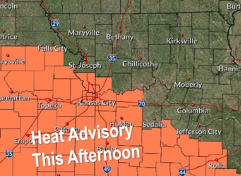
A heat advisory has been issued for Monday afternoon and Tuesday afternoon, according to the National Weather Service.
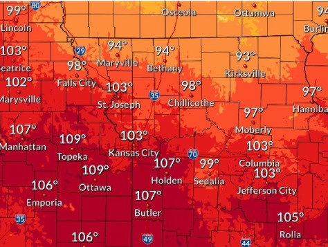
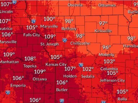
Temperatures on Monday will reach a high of 93, with a heat index as high as 103, the weather service said. The heat index will be in effect from 1 p.m. to 8 p.m. Monday.
On Tuesday, the high will be near 93 with a heat index as high as 105, according to the weather service. Another heat index has been issued for Tuesday.
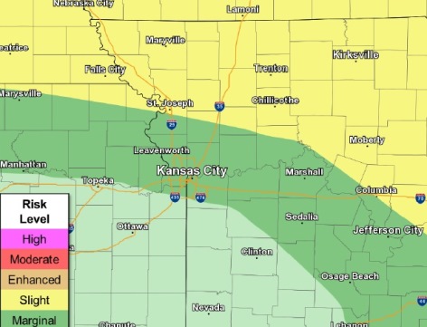
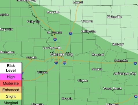
Thunderstorm chances return mid-week as a slow-moving cold front sags southward across the area, the weather service said.
Isolated severe weather will be possible mid-week, with locally gusty winds and hail, according to the weather service.
Hot temperatures and high humidity could quickly cause heat stress or heat stroke if precautions are not taken, the weather service said. The very young, the elderly, those without air conditioning and those participating in strenuous activities outdoors are at risk. Car interiors can reach lethal temperatures in a matter of minutes.
Residents are advised to drink plenty of fluids, stay in an air-conditioned room, stay out of the sun and check on relatives and neighbors, according to the weather service.
Those who work or spend time outdoors are advised to reschedule strenuous activities to early morning or late evening, wear lightweight and loose-fitting clothing and drink plenty of water. Those who work outdoors are advised to take frequent rest breaks in shaded or air-conditioned areas.
According to the weather service, the Missouri and Kansas rivers in Wyandotte County currently are below flood stage. The Missouri River at Parkville is in action stage, while the Kansas River was at action stage until Monday morning, when it went below action stage.
Today, the high will be near 93 with a heat index as high as 103, the weather service said. A calm wind will become east around 5 mph in the afternoon.
Tonight, it will be partly cloudy with a low of 73 and a southeast wind of 6 mph, according to the weather service.
Tuesday, it will be mostly sunny with a high near 93 and a heat index as high as 105, the weather service said. There will be a south southwest wind of 3 to 5 mph.
Tuesday night, there is a 30 percent chance of showers and thunderstorms, mainly after 1 a.m., according to the weather service. The low will be around 74 with a south southwest wind of 5 mph becoming calm in the evening.
Wednesday, there is a 60 percent chance of showers and thunderstorms likely, mainly after 1 p.m., the weather service said. The high will be near 86, with a light and variable wind. Between a half and three-quarters of an inch of rain is possible.
Wednesday night, there is a 60 percent chance of showers and thunderstorms, mainly after 1 a.m., according to the weather service. Some of the storms could produce heavy rainfall, with between 2 and 3 inches possible. The low will be around 68.
Thursday, there is a 50 percent chance of showers and thunderstorms before 1 p.m., with a high near 81, the weather service said.
Thursday night, there is a 30 percent chance of showers and thunderstorms after 1 a.m., with a low of 66, according to the weather service.
Friday, there is a 30 percent chance of showers and thunderstorms before 1 p.m., with a high near 82, the weather service said.
Friday night, it will be mostly cloudy with a low of 66, according to the weather service.
Saturday, there is a 30 percent chance of showers and thunderstorms, with a high near 83, the weather service said.
Saturday night, it will be partly cloudy with a low of 69, according to the weather service.
Sunday, it will be mostly sunny with a high of 86, the weather service said.
For more weather information, visit www.weather.gov.