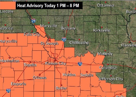
A heat advisory will be in effect from 1 p.m. to 8 p.m. Tuesday, Aug. 20, according to the National Weather Service.
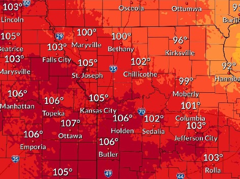
The heat index this afternoon could reach 103, the weather service said.
Periodic thunderstorm chances are expected mid-week for the area, according to the weather service. A cluster of storms this morning north of the Kansas City area are bringing gusty winds and heavy rainfall to Nebraska and Iowa.
Additional storms may develop in Iowa and move into the area on Wednesday morning, the weather service said.
Residents are advised to drink plenty of fluids, stay in an air-conditioned room, stay out of the sun and check on relatives and neighbors, according to the weather service. Those outdoors should take frequent rest breaks in shaded or air-conditioned environments. In the event of heat stroke, call 911.
The Missouri and Kansas rivers in Wyandotte County are currently below flood stage, according to hydrology charts. The Missouri River at Parkville, which includes the Wyandotte County area, was in the action stage on Tuesday morning and falling. The Kansas River at 23rd Street was below flood stage nad below action stage.
Today, it will be mostly sunny with a high near 93 and a heat index as high as 103, the weather service said. There will be a south southwest wind of 6 to 8 mph.
Tonight, there is a 30 percent chance of showers and thunderstorms after 1 a.m., according to the weather service. The low will be around 74 with a south southwest wind of 5 to 8 mph, becoming calm after midnight.
Wednesday, there is a 70 percent chance of showers and thunderstorms likely, mainly after 1 p.m., the weather service said. The high will be near 88 with a heat index as high as 96. There will be a light and variable wind. Between a quarter and half-inch of rain is possible.
Wednesday night, there is a 70 percent chance of showers and thunderstorms, some of which could produce heavy rainfall, according to the weather service. The low will be around 68 with a light east wind. Between 2 and 3 inches of rain are possible.
Thursday, there is a 60 percent chance of showers and thunderstorms, mainly before 1 p.m., the weather service said. The high will be near81 with a calm wind becoming east around 5 mph in the afternoon. Between three-quarters and one inch of rain is possible.
Thursday night, there is a 40 percent chance of showers and thunderstorms, with a low of 67, according to the weather service. Between a quarter and half-inch of rain is possible.
Friday, it will be mostly cloudy with a high near 81, the weather service said.
Friday night, it will be mostly cloudy with a low of 67, according to the weather service.
Saturday, it will be mostly cloudy with a high near 82, the weather service said.
Saturday night, it will be partly cloudy with a low of 68, according to the weather service.
Sunday, it will be mostly sunny with a high near 85, the weather service said.
Sunday night, there will be a 30 percent chance of showers and thunderstorms, with a low of 70, according to the weather service.
Monday, it will be mostly sunny with a high of 86, the weather service said.