Hazardous heat is expected both today and Thursday, according to the National Weather Service.
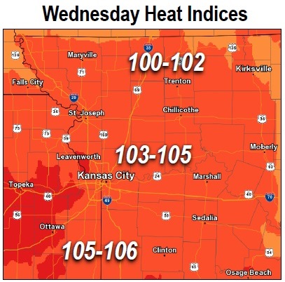
Wednesday afternoon temperatures will rise to the low to mid 90s, with a heat index between 100 and 106 degrees, the weather service said.
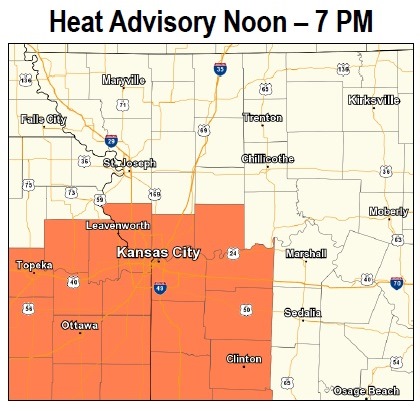
A heat advisory is in effect from noon to 7 p.m. today for Wyandotte County and the surrounding area, according to the weather service.
Afternoon highs will reach the mid-90s Thursday with heat index between 102 and 107 degrees, the weather service said.
Thunderstorms are possible this afternoon, though should remain isolated, according to the weather service. No severe weather is expected.
Those who are outdoors today should reschedule strenuous activities to early morning or evening if possible, the weather service said. Wear lightweight and loose-fitting clothing when possible and drink plenty of water today, the weather service advised.
Today, the high will be near 94, with a 20 percent chance of isolated showers and thunderstorms, according to the weather service. The heat index will be as high as 105, with a south wind of 6 to 9 mph.
Tonight, there is a 20 percent chance of showers and thunderstorms before 10 p.m., then a slight chance of showers after 1 a.m., according to the weather service. The low will be 77.
Thursday, it will be mostly sunny with a high near 95, and a heat index as high as 106, the weather service said. A south wind will be 7 to 11 mph.
Thursday night, there is a 50 percent chance of showers and thunderstorms with a low of 76 and a south wind of 6 to 9 mph, the weather service said.
Friday, expect a 50 percent chance of showers and thunderstorms, with a high near 86, according to the weather service. The wind will be west southwest at 5 to 7 mph changing to north northwest in the afternoon.
Friday night, there will be a 30 percent chance of showers and thunderstorms before 1 a.m., according to the weather service. The low will be around 71.