A little bit of everything is in today’s forecast – dangerous heat, with the possibility of severe storms here and flash flooding to the north, according to the National Weather Service.
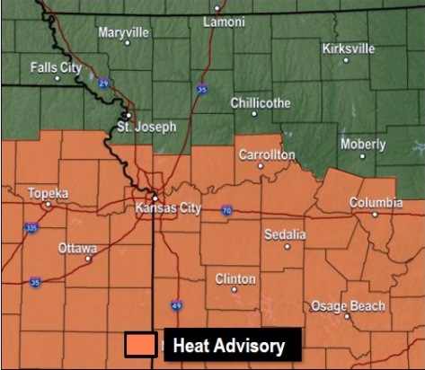
A heat advisory is in effect until 8 p.m. Wednesday, July 26, the weather service said.
Residents are advised to drink plenty of fluids, stay in an air-conditioned room, stay out of the sun and check on relatives and neighbors, according to the weather service. Objects in the sunlight could be very hot to the touch and could lead to burns on the skin. Animals left outside could experience heat related illnesses, according to the weather service.
It will cool down to the 80s on Thursday, the weather service said.
A storm system is currently in the Manhattan, Topeka and Leavenworth, Kansas, area and appears to be moving toward the northwest, according to a weather service radar map. It could be moving toward parts of Wyandotte County.
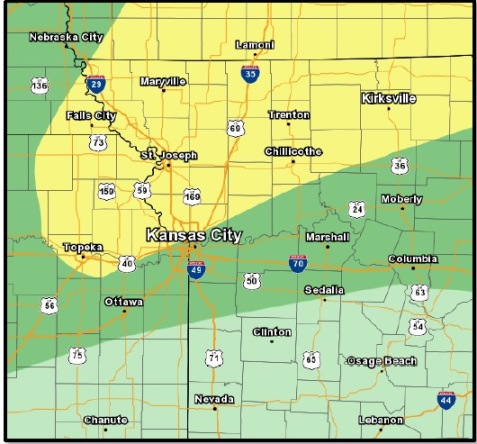
Severe thunderstorms are possible this afternoon and evening in parts of the region, the weather service said. Damaging winds and frequent lightning are possible with these storms.
In addition, flash flooding is possible with as much as 3 inches of rain an hour and widespread rain amounts of 2 to 4 inches in some parts of the region, mostly north of Wyandotte County in the St. Joseph, Mo., area, according to the weather service.
Today in Wyandotte County, there is a 30 percent chance of showers and thunderstorms before 4 p.m., then a slight chance of showers and thunderstorms after 5 p.m., the weather service said. The high will be near 93 with a heat index as high as 106.
Tonight, there is a 50 percent chance of showers and thunderstorms, mainly after 8 p.m., according to the weather service. It will be mostly cloudy with a low of 74, and a south wind of 5 to 10 mph, becoming north northwest after midnight. Between a tenth and quarter of an inch of rain is predicted.
Thursday, there is a 30 percent chance of showers and thunderstorms, mainly before 1 p.m., the weather service said. The high will be near 85 with mostly cloudy skies. Less than a tenth of an inch of rain is expected to fall.
Thursday night, it will be partly cloudy with a low of around 68, according to the weather service, and a north northeast wind of 5 to 7 mph.
Friday, it will be mostly sunny with a high near 85, the weather service said, and a northeast wind of 5 to 7 mph.
Friday night, expect mostly clear skies with a low of 65, according to the weather service.
Saturday, it will be mostly sunny with a high near 83, the weather service said.
Saturday night, the low will be around 64 with mostly clear skies, according to the weather service.
Sunday, expect mostly sunny skies with a high near 84, the weather service said.
For more weather information, visit www.weather.gov.