A heat advisory for Wyandotte County and the surrounding area has been extended until 8 p.m. Wednesday, June 15, according to the National Weather Service.
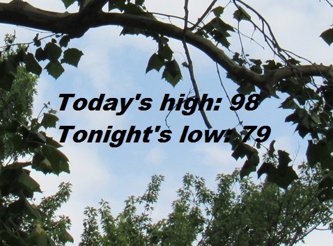
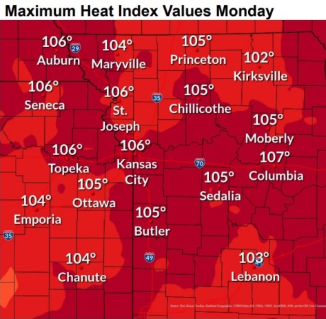
Continued hot weather is in the forecast today and this week, the weather service said. The high may reach 98 with a heat index as high as 106. It was 84 degrees with a heat index of 90 at 9 a.m. Monday.
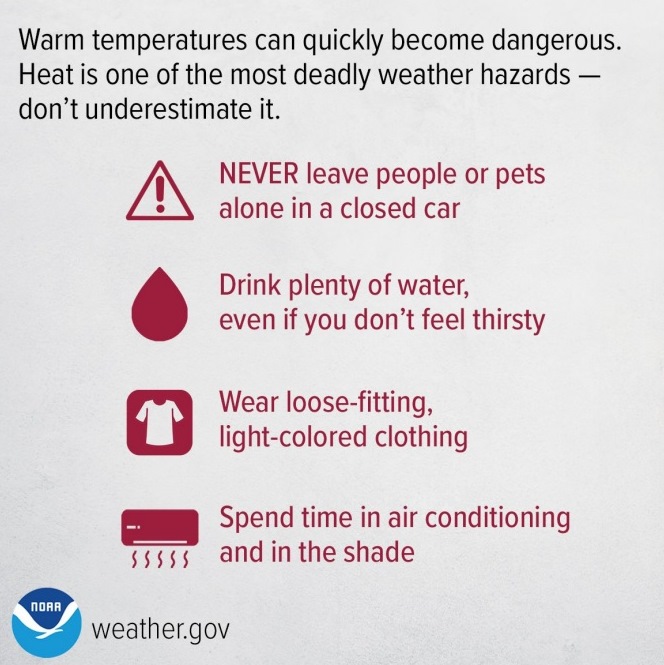
High temperatures and humidity could cause heat illnesses, according to the weather service. Residents are advised to drink plenty of fluids, stay in an air-conditioned room, stay out of the sun and check on relatives and neighbors.
Young children and pets should never be left unattended in vehicles.
Those who work or spend time outside should take extra precautions, the weather service said. When possible, reschedule strenuous activities to early morning or evening. Wear lightweight and loose-fitting clothing when possible. To reduce risk during outdoor work, the Occupational Safety and Health Administration recommends scheduling frequent rest breaks in shaded or air-conditioned environments.
Anyone overcome by heat should be moved to a cool and shaded location. Call 911 if you think it is heat stroke.
Today, it will be mostly sunny and hot, with a high near 98 and heat index values as high as 106, the weather service said. A south southwest wind of 13 to 17 mph will gust as high as 33 mph.
Tonight, it will be mostly clear, with a low of 79 and a south wind of 16 mph, gusting as high as 31 mph, according to the weather service.
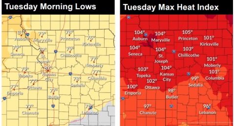
Tuesday, it will be sunny, with a high near 96 and heat index values as high as 104, the weather service said. A south southwest wind of 15 to 21 mph will gust as high as 34 mph.
Tuesday night, it will be mostly clear, with a low of 77 and a south wind of 10 to 14 mph, gusting as high as 22 mph, according to the weather service.
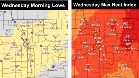
Wednesday, there is a 20 percent chance of showers between 1 p.m. and 4 p.m., then a slight chance of showers and thunderstorms after 4 p.m., the weather service said. It will be sunny, with a high near 95. A south southwest wind of 10 to 16 mph will gust as high as 30 mph.
Wednesday night, there is a 40 percent chance of showers and thunderstorms, mainly before 1 a.m., according to the weather service. The low will be around 71. Between a half and three-quarters of an inch of rain is possible.
Thursday, it will be mostly sunny, with a high near 93, the weather service said.
Thursday night, it will be mostly clear, with a low of 69, according to the weather service.
Friday, it will be sunny, with a high near 91, the weather service said.
Friday night, it will be clear with a low of 67, according to the weather service.
Saturday, it will be sunny, with a high near 92, the weather service said.
Saturday night, it will be clear, with a low of 69, according to the weather service.
Sunday, it will be sunny, with a high near 93, the weather service said.
For more weather information, see www.weather.gov.