Rain, lightning and thunder moved through Wyandotte County on Friday morning, with freezing rain and heavy snow forecast for Friday night and Saturday.
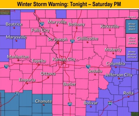
According to the National Weather Service forecast, a winter storm warning will be in effect from 6 p.m. Friday to 6 p.m. Saturday in Wyandotte County and the surrounding region. A cold front is moving into the area, extending from the Great Lakes through eastern Kansas.
Travel could be very difficult from Friday night through Saturday night, the weather service said. Blowing snow may significantly reduce visibility.
Also, temperatures will drop rapidly after sunset Friday, which could cause a flash freeze of any liquid water on the roads and elevated surfaces, in combination with the wintry mix already falling, according to the weather service.
Those who must travel should keep an extra flashlight, food and water in their vehicles in case of an emergency, the weather service said.
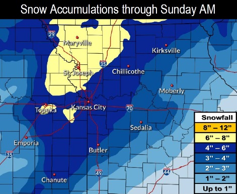
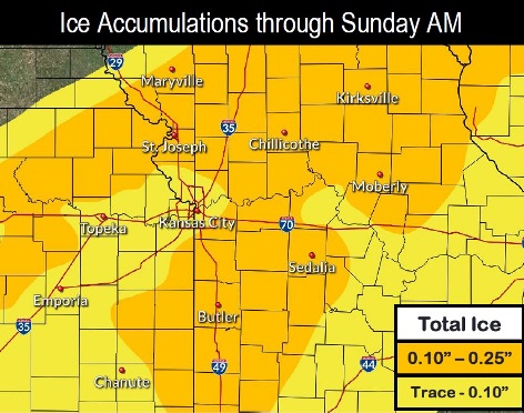
Currently, the forecast is calling for 4 to 6 inches of snow in Wyandotte County on Saturday, but that could change. According to the weather service, the axis of heaviest snow has shifted northward in the latest forecast, and there will be an increase in ice accumulations to the north of the region.
Rain may continue through the day Friday. Temperatures will be around 39 to 41 degrees throughout much of the daytime Friday, then temperatures will start falling in the afternoon, around 39 at 2 p.m., and could be at 34 degrees by 5 p.m. Freezing rain could start around 5:30 p.m. Friday, with snow starting around 10:30 p.m. or 11 p.m. Those times are only estimates.
For more up-to-date weather reports, check the weather service website at www.weather.gov.
Today, there will be rain, mainly after 11 a.m., the weather service said. Temperatures will rise to nearly 41 degrees by noon, then fall to around 34 during the remainder of the day. It will be breezy, with a north wind of 8 to 13 mph increasing to 15 to 20 mph in the afternoon. Winds may gust as high as 30 mph. Between a half and three-quarters of an inch of rain is possible.
Tonight, there is a 100 percent chance of freezing rain and sleet, possibly mixed with snow, becoming all snow after 11 p.m., according to the weather service. The low will be around 19. It will be blustery, with a north wind of 18 to 22 mph, gusting as high as 34 mph. New ice accumulation of less than one-tenth of an inch is possible. New snow and sleet accumulation of around an inch is possible.
Saturday, there is a 90 percent chance of snow before 5 p.m., then snow, possibly mixed with freezing rain, the weather service said. The snow could be heavy at times. Patchy blowing snow is possible before noon, with a high of 23. A north wind will be 9 to 18 mph, gusting as high as 30 mph. Little or no ice accumulation is expected. New snow accumulation of 3 to 7 inches is possible.
Saturday night, it will be partly cloudy, with a low of 9 and a northwest wind of 6 mph becoming calm in the evening, according to the weather service.
Sunday, there is a 20 percent chance of snow before 3 p.m., then a slight chance of rain and snow between 3 p.m. and 4 p.m., then a slight chance of rain after 4 p.m., the weather service said. The high will be near 35 with a calm wind becoming southeast around 5 mph.
Sunday night, it will be partly cloudy, with a low of 18, according to the weather service.
Monday, it will be mostly sunny, with a high near 43, the weather service said.
Monday night, it will be mostly cloudy, with a low of 31, according to the weather service.
Tuesday, it will be mostly sunny, with a high near 44, the weather service said.
Tuesday night, it will be partly cloudy, with a low of 23, according to the weather service.
Wednesday, it will be partly sunny, with a high near 36, the weather service said.
Wednesday night, it will be partly cloudy, with a low of 12, according to the weather service.
Thursday, it will be mostly sunny, with a high near 29, the weather service said.
More weather information is available at https://www.weather.gov/eax/hwo.