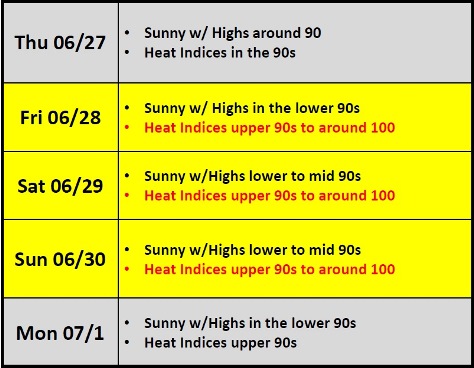
National Weather Service forecasters are predicting a heat index of 99 today.
Hot weather may continue through the weekend, according to the forecast.
Afternoon highs may rise to 91 today, with the heat index approaching the century mark. It will be the region’s first run of multiple days of dangerously hot and humid temperatures this summer, the weather service said.
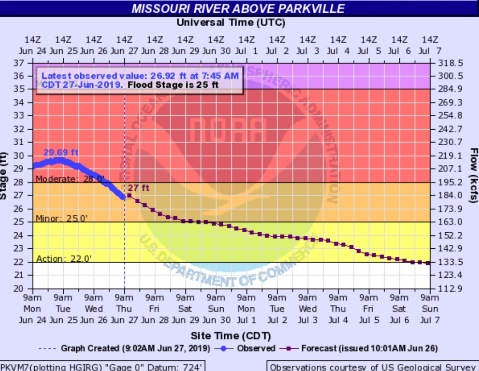
With the dry weather of the past few days, the Missouri River at Parkville, which includes Wyandotte County, has fallen from moderate to minor flood stage, according to hydrology charts.
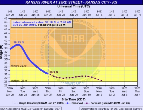
The Kansas River at 23rd Street, where the gauge is at Kansas Avenue and the state line, has fallen from minor flood stage into action stage, hydrology charts showed.
At a news conference on Wednesday, the Army Corps of Engineers stated that as the river levels are declining, they are making adjustments to the amount of water being released from reservoirs.
The Gavins Point dam in South Dakota, which is upstream on the Missouri River, will release 70,000 cfs, a decrease of 5,000 cfs, beginning today, and will probably hold that level of releases through the end of July, a corps official said. The mountain snowpack to the north, which results in runoff to the reservoirs, is almost all melted.
With no rain in the forecast, reservoirs in Kansas will release more water into the rivers. There may be some changes to the Kansas River in the next few days, based on water releases.
Kansas area reservoirs will be increasing releases based on the declining water levels and the forecast of dry weather. The Missouri River crest has now passed Waverly, Missouri, according to officials.
Perry, which is about 98 percent occupied of its flood control pool, went from a release of 2,000 cfs to 4,000 cfs on Wednesday, officials said. Tuttle Creek increased releases from 5,000 to 8,000 cfs, and it will take more than three days for the water to reach the Missouri River, according to officials. Milford went from 5,000 cfs to 7,000 cfs on Wednesday, with a travel time of more than four days to the Missouri River.
In the Osage basin, Truman reservoir will continue releasing 45,000 cfs for the next few days, according to officials. Other Osage basin reservoirs also are making releases.
The National Weather Service forecast for Wyandotte County has no rain predicted through the next seven days, although there is the possibility of some occasional scattered showers.
Today, it will be sunny with a high near 91 and a heat index as high as 99, the weather service said. A south wind of 8 to 14 mph will gust as high as 21 mph.
Tonight, it will be mostly clear, with a low of 72 and a south wind of 8 to 10 mph, gusting as high as 20 mph, according to the weather service.
Friday, it will be sunny with a high near 94 and heat index values as high as 102, the weather service said. A south southwest wind of 8 to 14 mph will gust as high as 18 mph.
Friday night, it will be mostly clear, with a low of 73 and a south wind of 3 to 5 mph, according to the weather service.
Saturday, it will be sunny with a high near 95 and a south wind of 3 to 5 mph, the weather service said.
Saturday night, it will be mostly clear with a low of 72, according to the weather service.
Sunday, it will be sunny with a high near 94, the weather service said.
Sunday night, it will be mostly clear with a low of 72, according to the weather service.
Monday, it will be sunny with a high near 93, the weather service said.
Monday night, it will be mostly clear with a low of 72, according to the weather service.
Tuesday, it will be mostly sunny, with a high near 92, the weather service said.
Tuesday night, it will be partly cloudy, with a low of 72, according to the weather service.
Wednesday, it will be mostly sunny, with a high of 91, the weather service said.