Today’s weather forecast from the National Weather Service is sunny, a high near 81 and winds gusting to 20 mph.
A cold front is moving through the region, but doesn’t bring a sharp change in temperatures, according to the weather service.
It will bring a 20-degree drop in dewpoints over the next day, making temperatures in the upper 70s feel more like fall, the weather service said.
The drier weather will not last long, with dewpoints climbing back into the upper 60s Friday with a southerly return flow on the back of the surface high pressure, according to the weather service.
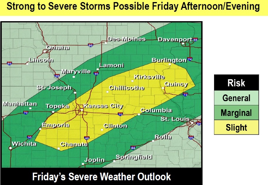
The weather will change on Thursday night, when there is a 30 percent chance of showers and storms, rising to 60 percent on Friday.
The weekend rains might bring 2 inches or more of rain, according to the forecast.
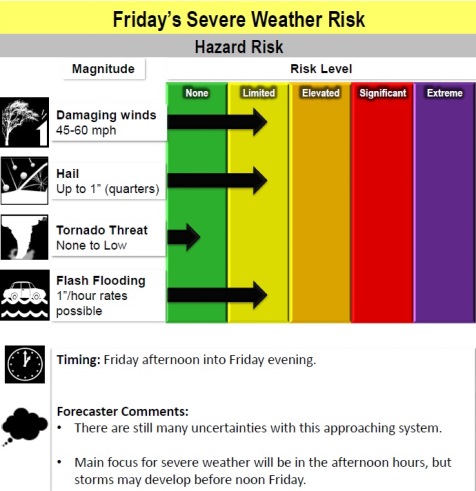
The main risk of the Friday storms will be damaging winds, large hail and flash flooding, the weather service said.
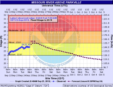
Missouri River flooding could be affected by the rainfall, according to the weather service. On Wednesday morning, the Missouri River at Parkville, where the gauge is on I-435 between Wyandotte County and Platte County, was in action stage at 24.04 feet. Minor flood stage is 25 feet.
Today, it will be partly sunny, then becoming sunny, with a high near 81, the weather service said. A northwest wind of 6 to 10 mph will become north northeast in the afternoon, gusting as high as 20 mph.
Tonight, it will be mostly clear, with a low of 57 and a north northeast wind of 5 to 7 mph, according to the weather service.
Thursday, it will be sunny with a high near 77 and light and variable wind becoming southeast 5 to 9 mph in the morning, the weather service said.
Thursday night, there is a 30 percent chance of showers and thunderstorms after 1 a.m., with a low of 70, according to the weather service. A south wind of 6 to 11 mph will gust as high as 24 mph.
Friday, there is a 60 percent chance of showers and thunderstorms, mainly after 1 p.m., the weather service said. The high will be near 83 with a southwest wind of 8 to 14 mph, gusting to 29 mph. Between a half and three-quarters inch of rain is possible.
Friday night, there is a 70 percent chance of showers and thunderstorms, mainly before 1 a.m., according to the weather service. The low will be around 59 with between three-quarters and one inch of rain possible.
Saturday, there is a 40 percent chance of showers and thunderstorms, with a high near 73, the weather service said.
Saturday night, there is a 50 percent chance of showers and thunderstorms, with a low of 67, according to the weather service.
Sunday, there is a 30 percent chance of showers and thunderstorms before 1 p.m., with a high near 83, the weather service said.
Sunday night, it will be mostly cloudy, with a low of 73, according to the weather service.
Monday, it will be partly sunny, with a high near 84, the weather service said.
Monday night, it will be mostly cloudy, with a low of 72, according to the weather service.
Tuesday, there is a 40 percent chance of showers and thunderstorms, with a high near 82.