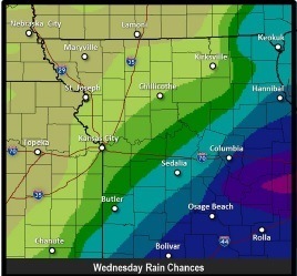
Scattered thunderstorms are again expected today and again on Thursday, according to the National Weather Service.
There is a 30 percent chance of showers and thunderstorms, mainly after noon, the weather service said. Today’s high will be near 83, with a south southwest wind around 7 mph.
Locally heavy rainfall is possible with these storms along with small hail and a few gusty winds, according to the weather service. Severe thunderstorms are not expected.
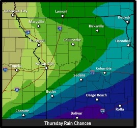
More widespread thunderstorm activity is expected to the southeast of the Kansas City area, and across the Missouri Ozarks, the weather service said.
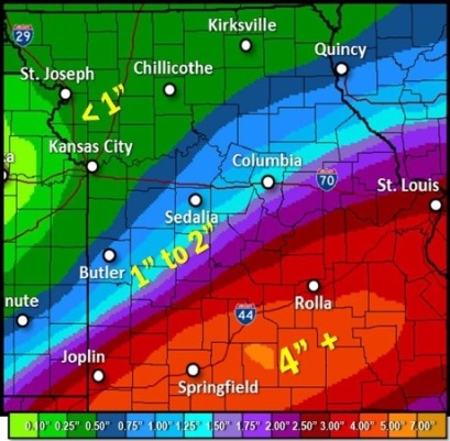
Remnants of Tropical Storm Bill will spread copious amounts of moisture into the Missouri Ozarks today through Friday morning where widespread heavy rain and flooding are possible, according to the weather service. While some of this rain may make it as far north as a Butler to Columbia line, most of the heavy rain will stay to the south of the forecast area
On Thursday, Wyandotte County can expect a 30 percent chance of showers and thunderstorms, according to the weather service. The high will be near 82.
Thursday night, the low temperature will be 68, the weather service said.
Friday’s high will be near 83, according to the weather service. Skies will be partly sunny.
Friday night’s low will be around 70.
Saturday, expect mostly sunny skies with a high near 91, the weather service said.
Saturday night, there is a 40 percent chance of showers and thunderstorms, according to the weather service. The low will be around 73.