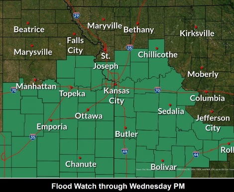
A flood watch remains in effect through 7 p.m. Wednesday, according to the National Weather Service.
Additional showers and storms are possible through the day Wednesday, and while new rain amounts will be lower, any additional rain will exacerbate ongoing flooding across the area, the weather service said.
Rain chances will end by this Wednesday with dry weather returning for Thursday and Friday, according to the weather service. More rain is possible Saturday, Sunday and next week.
The weather service stated that excessive runoff could result in flooding of rivers, creeks, streams and other low-lying and flood-prone locations.
Residents should monitor later forecasts and be alert for possible flood warnings, according to the weather service. Those living in areas prone to flooding should be prepared to take action should flooding develop.
At 8 a.m. Wednesday, the Missouri and Kansas rivers in Wyandotte County were still under the action stage, according to hydrology charts from the National Oceanic and Atmospheric Administration.
Stranger Creek near Easton, Kansas, was in moderate flood stage, and Stranger Creek near Tonganoxie, Kansas, was in the action stage, according to hydrology charts.
By 8 a.m. Wednesday, storm clouds had shifted to the east and south of the Wyandotte County area. However, more rain could fall this afternoon and evening, according to the forecast.
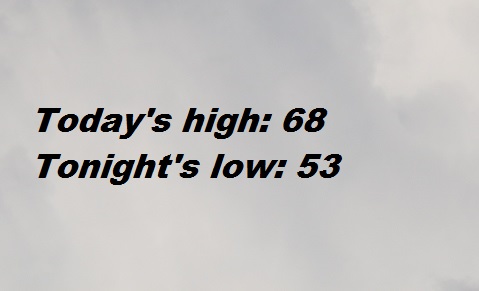
Today, there is a 60 percent chance of showers and thunderstorms after 3 p.m., with some storms producing heavy rain, the weather service said. The high will be near 68 with a north northeast wind of 5 to 9 mph. Between a tenth and quarter-inch of rain are possible.
Tonight, there is a 40 percent chance of showers and thunderstorms, mainly before 10 p.m., according to the weather service. The low will be around 53 with a north wind of 6 to 9 mph, gusting as high as 18 mph. Less than a tenth of an inch of rain is in the forecast.
Thursday, it will be sunny, with a high near 73 and a north wind of 5 to 7 mph, the weather service said.
Thursday night, it will be clear, with a low of 54 and a calm wind, according to the weather service.
Friday, it will be sunny, with a high near 79 and a calm wind becoming south around 6 mph in the afternoon, the weather service said.
Friday night, it will be mostly clear, with a low of 59, according to the weather service.
Saturday, there is a 40 percent chance of showers, with a high near 77, the weather service said.
Saturday night, there is a 60 percent chance of showers, then showers are likely and possibly a thunderstorm after 1 a.m., according to the weather service. The low will be around 63.
Sunday, there is a 30 percent chance of showers before 1 p.m., with a high near 80, the weather service said.
Sunday night, there is a 40 percent chance of showers and thunderstorms, with a low of 65, accoding to the weather service.
Monday, there is a 30 percent chance of showers, with a high near 79, the weather service said.
Monday night, there is a 40 percent chance of showers, with a low of 63, according to the weather service.
Tuesday, there is a 30 percent chance of showers, with a high near 78, the weather service said.
For more weather information, visit www.weather.gov.