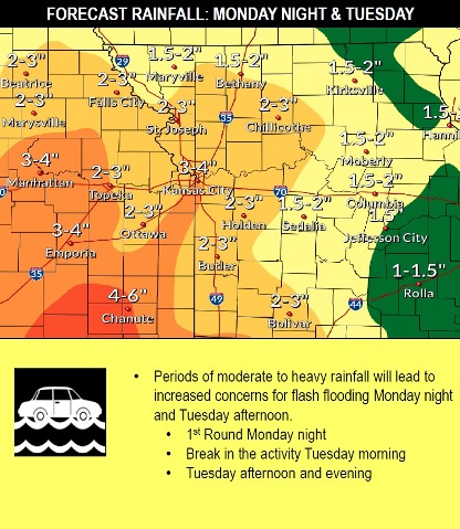
With moderate to heavy rain expected Monday night into Tuesday, a flash flood watch will be in effect from 7 p.m. May 20 through 7 p.m. May 21, according to the National Weather Service.
From 1 to 2 inches of rain are possible on Monday night, and 1 to 2 inches more rain on Tuesday, according to the forecast. Rain is in the forecast for the rest of the week, also.
The already saturated ground plus the rain may mean that flash flooding may quickly develop both Monday night and again Tuesday afternoon, the weather service said. There is still uncertainty as to where the highest precipitation will be.
The weather service advises residents not to drive through flooded roadways, but to turn around and take another route.
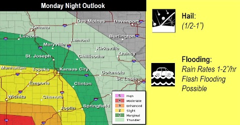
A severe weather threat will return Monday night and Tuesday, according to the weather service. Monday night, there may be large hail, heavy rainfall and flash flooding.
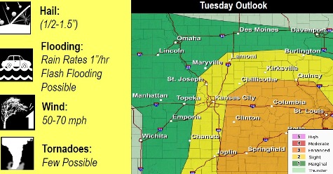
Tuesday afternoon, there may be large hail, damaging winds, a few tornadoes, heavy rainfall and flash flooding, the weather service said.
Points along the Missouri River will remain in flood stage for many more days, if not weeks. The Missouri River at Parkville, which covers the Wyandotte County area, is currently below the minor flood stage, and is in the action stage.
Today, there is a 40 percent chance of showers and thunderstorms, mostly after 3 p.m., the weather service said. The high will be near 62 with an east northeast wind of 6 to 10 mph. Less than a tenth of an inch of rain is possible.
Tonight, there is a 100 percent chance of showers and thunderstorms, with a low of 57, according to the weather service. An east northeast wind of 16 mph may gust as high as 28 mph. Between 1 and 2 inches of rain are possible.
Tuesday, there is an 80 percent chance of showers and thunderstorms, with a high near 70, the weather service said. An east southeast wind of 15 to 20 mph will gust as high as 29 mph. Between 1 and 2 inches of rain are possible.
Tuesday night, it will be partly cloudy, with a low of 58 and a south wind of 13 to 16 mph, gusting as high as 25 mph, according to the weather service.
Wednesday, it will be sunny with a high near 81 and a south southwest wind of 11 to 15 mph, gusting as high as 28 mph, the weather service said.
Wednesday night, there is a 50 percent chance of showers and thunderstorms, with a low of 67, according to the weather service. Between a quarter and half-inch of rain is possible.
Thursday, there is a 50 percent chance of showers and thunderstorms, with a high near 83, the weather service said.
Thursday night, it will be mostly cloudy with a low of 69, according to the weather service.
Friday, there is a 50 percent chance of showers, with thunderstorms also possible after 1 p.m.., the weather service said. The high will be near 78.
Friday night, there is an 80 percent chance of showers and thunderstorms, then showers and possibly a thunderstorm after 1 a.m., according to the weather service. The low will be around 66.
Saturday, there is a 60 percent chance of showers with a high near 79, the weather service said.
Saturday night, there is a 70 percent chance of showers, with a low of 64, according to the weather service.
Sunday, there is a 50 percent chance of showers, with a high near 81, the weather service said.
For more weather information, visit www.weather.gov or listen to a weather radio.