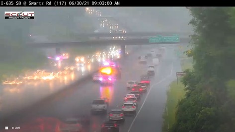
A flash flood warning has been issued for Wyandotte County and surrounding areas from 8:38 a.m. Wednesday through 12:30 p.m. Wednesday, according to the National Weather Service.
Other counties in the Kansas City metropolitan area also are under the flash flood warning.
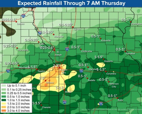
The weather service said radar and rain gauges indicated thunderstorms producing heavy rain across the area at 8:38 a.m. Between 1 and 2 inches of rain have fallen Wednesday morning.
Additional rainfall amounts of 1 to 2 inches are expected, and flash flooding is ongoing or expected to begin shortly, the weather service said.
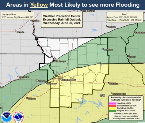
Kansas City, Kansas and Bonner Springs are among the many locations that will experience flash flooding, according to the weather service. Motorists should turn around and avoid areas where there is high water.
According to the weather service forecast, periods of moderate to heavy rain will continue Wednesday into Wednesday evening. Severe weather is not anticipated.
Ongoing minor to major flooding in the area could be aggravated, according to the weather service. As of 8:45 a.m. Wednesday, the Missouri and Kansas rivers in Wyandotte County were well below the action stage and flood stage.
Rain is expected into Thursday morning, but it will taper off through the day, leading to dry wether Friday through Sunday, the weather service said.
Today, there is an 80 percent chance of showers and a thunderstorm, mainly before 5 p.m., then more showers and thunderstorms likely after 5 p.m., the weather service said. Some storms could prduce heavy rain. The high will be near 81 with a light southeast wind. Between three-quarters and one inch of rain are possible.
Tonight, there is a 50 percent chance of showers and thunderstorms, with a low of 69 and a calm wind, according to the weather service. Between a half and three-quarters of an inch of rain are possible.
Thursday, there is a 30 percent chance of showers and thunderstorms, mainly before 1 p.m., with a high near 84, the weather service said. A calm wind will become northeast 5 to 7 mph in the morning. Less than a tenth of an inch of rain is expected.
Thursday night, it will be mostly clear and the low will be around 65 with a northeast wind of 5 to 7 mph becoming calm in the evening, according to the weather service.
Friday, it will be sunny, with a high near 83 and a calm wind becoming east northeast around 6 mph in the morning, the weather service said.
Friday night, it will be mostly clear, with a low of 62, according to the weather service.
Saturday, it will be sunny, with a high near 85, the weather service said.
Saturday night, it will be mostly clear, with a low of 64, according to the weather service.
Sunday, Independence Day, it will be sunny, with a high near 87, the weather service said.
Sunday night, it will be mostly clear, with a low of 68, according to the weather service.
Monday, it will be mostly sunny, with a high near 90, the weather service said.
Monday night, it will be mostly clear, with a low of 70, according to the weather service.
Tuesday, there is a 30 percent chance of showers and thunderstorms, with a high near 91, the weather service said.