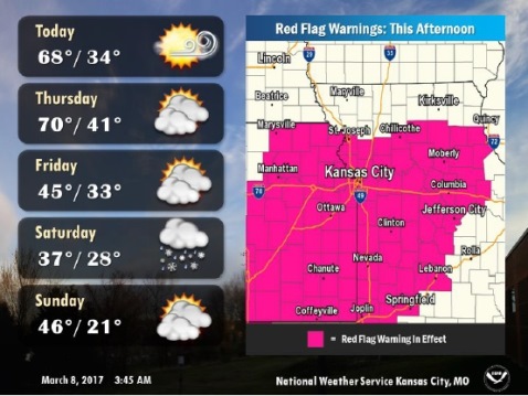
The National Weather Service has issued a red flag warning for extremely high fire danger this afternoon.
Warm and dry conditions with southwest winds around 20 mph gusting to 30 mph will lead to extremely high fire danger this afternoon, the weather service said.
The red flag warning is in effect from 11 a.m. to 6 p.m. today. Burning should be avoided, according to the weather service.
Any fuels that ignite will quickly burn out of control, the weather service said.
Wintry precipitation is likely across the area Friday night into Saturday, according to the weather service. Accumulating snow will be possible.
Today, it will be sunny with a high near 69, according to the weather service. A southwest wind of 9 to 14 mph will increase to 16 to 21 mph in the afternoon, gusting as high as 29 mph.
Tonight, it will be mostly clear, with a low of 42 and a southwest wind of 6 to10 mph, the weather service said.
Thursday, there is a 30 percent chance of rain after noon, according to the weather service. The high will be near 71. A south southwest wind of 7 mph will become north northwest in the afternoon.
Thursday night, expect mostly clear skies and a low of 34, the weather service said. There will be a north northeast wind of 6 to 11 mph.
Friday, it will be mostly sunny with a high near 47, according to the weather service. A northeast wind will be about 11 mph.
Friday night, there is a 50 percent chance of rain and snow between midnight and 2 a.m., then a chance of snow after 2 a.m. The low will be around 29.
Saturday, there is a 90 percent chance of snow before noon, then a chance of rain. The high will be near 37, the weather service said.
Saturday night, the low will be around 21 with partly cloudy skies.
Sunday, the forecast is most sunny skies with a high of 47, according to the weather service.
Sunday night, there is a 30 percent chance of snow after midnight with a low of 34, the weather service said.