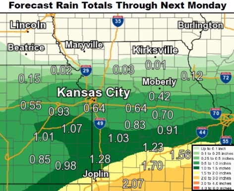
The National Weather Service says a strong storm system is expected to move into the lower Missouri Valley from Friday afternoon through much of the day on Saturday.
Periods of heavy rain with thunderstorms are possible for areas south of Route 50, according to the weather service.
Wyandotte County appears to be on the edge of this area and may get some rain and storms.
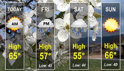
Today’s forecast is mostly cloudy and gradually becoming sunny, with a high near 66, the weather service said. A north northwest wind of 6 to 11 mph is in the forecast.
Tonight, it will be mostly clear with a low around 47, according to the weather service, and a northeast wind of 5 to 7 mph.
Friday, there is a 50 percent chance of showers, mainly after 1 p.m., the weather service said. The high will be near 58 and an east northeast wind of 6 to 13 mph.
On Friday night, there is an 80 percent chance of showers with a low of 45 and a northeast wind of 11 mph, according to the weather service. Between a quarter and a half-inch of rain is possible.
Saturday, there is a 50 percent chance of showers, mainly before 1 p.m., with a high near 55, the weather service said. There is a north northeast wind of 11 to 15 mph gusting as high as 21 mph.
Saturday night, expect mostly clear skies with a low of 41, according to the weather service.
Sunday, it will be sunny with a high near 67, the weather service said.
Sunday night, it will be mostly clear with a low of 47, according to the weather service.
For more information, visit www.weather.gov.