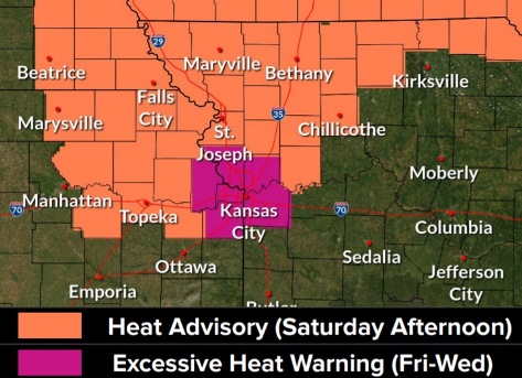
The National Weather Service has issued an excessive heat warning for 1 p.m. Friday, July 23, through 7 p.m. Wednesday, July 28.
Dangerously hot conditions are in the forecast, the weather service said.
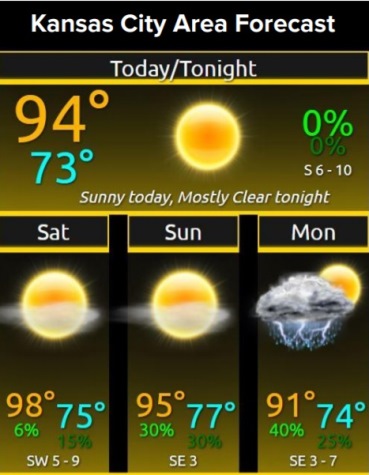
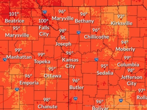
Today, temperatures will climb to 94, with a heat index of 97, the weather service said.
The heat index could rise into to the 100s on Saturday, with hot weather persisting through Wednesday, according to the weather service.
The weather service said extreme heat and humidity will significantly increase the potential for heat-related illnesses, particularly for those working or participating in outdoor activities.
Residents are advised to drink plenty of fluids, stay in an air-conditioned room, stay out of the sun and check up on relatives and neighbors, according to the weather service. Young children and pets should never be left unattended in vehicles under any circumstances.
Those who are working or spending time outside should take extra precautions, the weather service said. When possible, reschedule strenuous activities to early morning or evening.
Know the signs and symptoms of heat exhaustion and heat stroke, the weather service said. Wear lightweight and loose-fitting clothing when possible. To reduce risk during outdoor work, the Occupational Safety and Health Administration recommends scheduling frequent rest breaks in shaded or air-conditioned environments. Anyone overcome by heat should be moved to a cool and shaded location, the weather service said. Heat stroke is an emergency, and residents may call 911.
Cooling centers in Wyandotte County are at community centers and other locations. They have been posted by the Unified Government at https://unifiedgov.maps.arcgis.com/apps/LocalPerspective/index.html?appid=05d96f432cd645f6a59512875df09d6b.
Today, it will be sunny, with a high near 94 and heat index values as high as 97, the weather service said. There will be a south southwest wind of 7 to 9 mph.
Tonight, it will be mostly clear, with a low of 74 and a south wind of 6 to 8 mph, according to the weather service.
Saturday, it will be sunny, with a high near 96 and heat index values as high as 102 or 103, the weather service said. A southwest wind will be around 8 mph.
Saturday night, it will be mostly clear, with a low of 76 and a southwest wind around 6 mph becoming calm after midnight.
Sunday, there is a 30 percent chance of showers and thunderstorms after 1 p.m., with a high near 95, the weather service said, with a light and variable wind. New rainfall amounts of less than a tenth of an inch are expected.
Sunday night, there is a 30 percent chance of showers and thunderstorms after 1 a.m., with a low of 74, according to the weather service. The low will be around 74. Less than a tenth of an inch of rain is expected.
Monday, there is a 40 percent chance of showers and thunderstorms, with a high near 91, the weather service said.
Monday night, it will be mostly clear, with a low of 73, according to the weather service.
Tuesday, it will be sunny, with a high near 95, the weather service said.
Tuesday night, it will be mostly clear, with a low of 75, according to the weather service.
Wednesday, it will be sunny and hot, with a high near 98, the weather service said.
Wednesday night, it will be mostly clear, with a low of 77, according to the weather service.
Thursday, it will be sunny and hot, with a high near 98, the weather service said.