
A heat advisory is in effect today until noon, when it will change to an excessive heat warning, according to the National Weather Service. The excessive heat warning will be in effect from noon until 9 p.m. today.
Dangerously warm temperatures will prevail across the region today as highs soar into the middle to upper 90s, according to the weather service.
These temperatures combined with mid to upper 70 degree dewpoints will result in heat index values rising above 110 degrees this afternoon, the weather service said.
Today’s high of 96 may result in a heat index as high as 111 in Kansas City, Kan., the weather service said. A southwest wind will be 7 to 9 mph.
Tonight, there will be a 20 percent chance of showers and storms before 4 a.m., according to the weather service. The low will be 76.
Tuesday, it will be mostly sunny with a high near 93, and a heat index of 100, the weather service said.
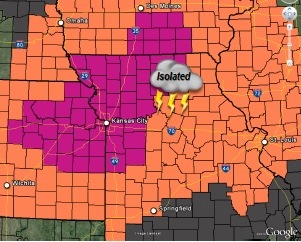
Isolated storms will remain possible on Tuesday in the region, with coverage increasing late Wednesday as an upper disturbance approaches, according to the weather service.
The weather service said those who work or spend time outside today should try to reschedule strenuous activities to early morning or late evening.
Residents should know the signs of heat exhaustion and heat stroke, wear lightweight and loose-fitting clothes, and drink plenty of water.
Anyone outside should take frequent rest breaks in the shade or air-conditioned rooms, according to the weather service. Anyone overcome by heat should be moved to a cool and shaded location. Heat stroke is an emergency, call 911.