Heat advisory in effect this afternoon
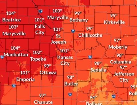
Temperatures in the upper 90s to lower 100s, combined with increasing humidity, will create dangerous heat today, according to the National Weather Service.
A heat advisory is in effect from 1 p.m. to 7 p.m. Thursday, June 17, in Wyandotte County, and also in the Kansas City metropolitan area, the weather service said.
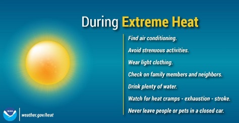
The weather service advised people to stay in cool areas and prevent heat-related illnesses.
Those who have to work outside or who are participating in outdoor activities should take frequent breaks, rest in the shade or cooler environment and drink plenty of water, according to the weather service.
Never leave children, pets or others alone in closed vehicles, the weather service said. Within minutes, the temperature inside a car can reach over 140 degrees, and it could be fatal.
If there are kids in the back seat of the car, put a phone, purse or wallet with them to remember not to leave them in the car, according to the weather service.
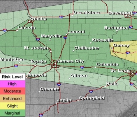
A few late night storms could be strong to severe on Friday night, the weather service said.
Look for temperature highs to returns to the 80s on Monday.
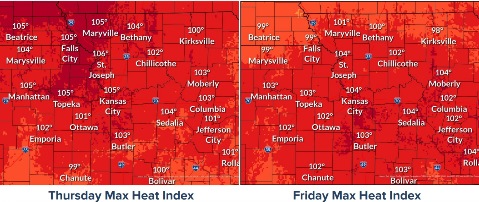
Today, it will be sunny and hot, with a high near 99 and heat index values as high as 104, the weather service said. A southwest wind of 5 to 13 mph will gust as high as 21 mph.
Tonight, the low will be around 77 with a south southwest wind of 9 to 13 mph, gusting as high as 21 mph.
Friday, it will be sunny and hot, with a high near 100, the weather service said. The heat index may be as high as 104. A southwest wind around 11 mph will gust as high as 20 mph.
Friday night, there is a 20 percent chance of showers and thunderstorms, with a low of 75, according to the weather service. There will be a south southwest wind of 6 to 8 mph.
Saturday, it will be mostly sunny, with a high near 95 and a south southwest wind of 5 to 7 mph, the weather service said.
Saturday night, there is a 20 percent chance of showers and thunderstorms between 1 a.m. and 4 a.m., then a slight chance of showers after 4 a.m., according to the weather service. The low will be around 75.
Sunday, it will be mostly sunny, with a high near 94, the weather service said.
Sunday night, there is a 50 percent chance of showers with a low of 67, according to the weather service.
Monday, there is a 30 percent chance of showers before 1 p.m., with a high near 81, the weather service said.
Monday night, it will be mostly clear, with a low of 54, according to the weather service.
Tuesday, it will be sunny, with a high near 79, the weather service said.
Tuesday night, it will be mostly clear, with a low of 58, according to the weather service.
Wednesday, it will be sunny, with a high near 84, the weather service said.
For more weather information, visit www.weather.gov.