An excessive heat warning is in effect today in Wyandotte County, and remains in effect through 8 p.m. Saturday, according to the National Weather Service.
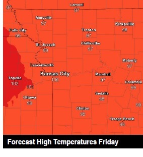
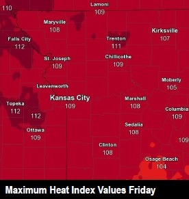
Temperatures may reach 99 today in Wyandotte County, with a heat index of 109, the weather service said.
Conditions are particularly dangerous in urban areas where temperatures may not drop below the lower 80s overnight, according to the weather service.
A cold front will bring relief from the heat by Saturday evening, the weather service said. The highs Sunday through Tuesday will be in the upper 80s.
A few strong storms are possible Saturday evening and overnight, particularly to the north, according to the weather service. Locally heavy rain and strong wind are the main threats.
With the excessive heat warning in effect today, the local cooling centers have opened.
The weather service advises residents to take extra precautions. Those who work or spend time outside should reschedule strenuous activities to early morning or evening, the weather service said. They should wear lightweight and loose-fitting clothing and drink plenty of water. Anyone overcome by heat should be moved to a cool and shaded location. If there are symptoms of heat stroke, residents should call 911. Also, young children and pets should never be left unattended in a vehicle, as the temperature inside heats up quickly.
The weather service also advised to stay in air-conditioning, stay out of the sun and check on relatives and neighbors.
Today, it will be sunny and hot, with a high near 99, the weather service said. The heat index may be as high as 109. There will be a south southwest wind of 6 to 10 mph.
Tonight, the low will be around 79 with a south wind of 6 to 10 mph, according to the weather service.
Saturday, it will be sunny and hot, with a high of 99, the weather service said. The heat index may rise to 107. There will be a west southwest wind of 7 to 10 mph. There is a 20 percent chance of showers and thunderstorms after 1 p.m.
Saturday night, expect a 40 percent chance of showers and thunderstorms, according to the weather service. The low will be around 74, with a west wind of 6 mph becoming light and variable in the evening. Between a quarter and a half-inch of rain is possible.
On Sunday, there is a 20 percent chance of showers and thunderstorms, the weather service said. The high will be near 90 with a light and variable wind becoming west southwest around 5 mph.
Sunday night, it will be partly cloudy with a low of 70, according to the weather service.
Monday, expect sunny skies with a high near 87, the weather service said.
Monday night, it will be mostly clear with a low of 68, according to the weather service.
For more weather information, visit www.weather.gov.