Dangerous cold air and wind chills will continue through the rest of the week and through the weekend, according to the National Weather Service forecast.
Saturday and Sunday could be the most dangerous stretch of this cold air outbreak, with an arctic high pressure system over the region, the weather service said.
Saturday and Sunday will be at the end of an eight to 10-day stretch of sub-freezing temperatures, and also will have the coldest air mass and wind chills of the outbreak, according to the weather service. Wind chills could dip as low as 20 or 30 below zero in the region.
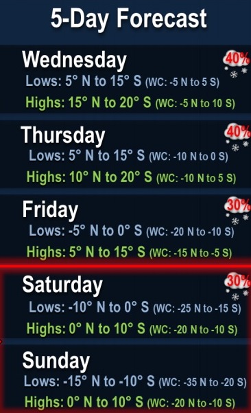
There are other chances for snow this week, including Wednesday and Thursday, the weather service said. Snow is in the forecast again on Friday and Saturday.
Today, roads could still be hazardous with the cold temperatures, and motorists are advised to be careful, according to the weather service.
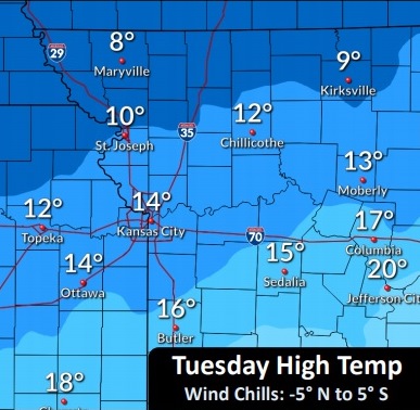
At 9 a.m. Tuesday, the temperature was 8 degrees with a wind chill of minus 5, the weather service said.
Today, it will be cloudy and cold, with a high near 13, and wind chill values between minus 8 and zero, the weather service said. A north northeast wind will be around 8 mph.
Tonight, there is a 20 percent chance of flurries between midnight and 3 a.m., then a slight chance of snow after 3 a.m., according to the weather service. The low will be around 8 with wind chill values between minus 2 and 3, and a northeast wind will be 7 to 9 mph.
Wednesday, there is a 20 percent chance of snow, with a high near 18, the weather service said. Wind chill values will be between zero and 7, with a northeast wind of 8 to 10 mph.
Wednesday night, there is a 20 percent chance of flurries before midnight, with a slight chance of snow after midnight, according to the weather service. The low will be around 9 with wind chill values between minus 3 and 7, and a northeast wind of 8 to 10 mph.
Thursday, there is a 20 percent chance of snow, with a high near 15, the weather service said. A north northeast wind will be around 11 mph.
Thursday night, it will be mostly cloudy, with a low of minus 1, according to the weather service.
Friday, there is a 30 percent chance of snow after noon, with a high near 8, the weather service said.
Friday night, there is a 30 percent chance of snow, with a low of minus 3, according to the weather service.
Saturday, there is a 30 percent chance of snow before noon, with a high near 5, the weather service said.
Saturday night, it will be mostly cloudy, with a low of minus 11, according to the weather service.
Sunday, it will be partly sunny and cold, with a high near 5, the weather service said.
Sunday night, it will be mostly cloudy, with a low of minus 7, according to the weather service.
On Monday, Washington’s Birthday, it will be mostly cloudy and cold, with a high near 12, the weather service said.