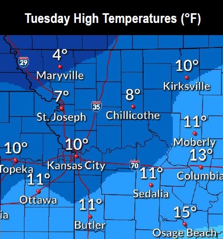
Dangerously cold temperatures continue today, according to the National Weather Service.
The temperature was minus 4 at 10 a.m., and today’s high will be near 10, the weather service said. The lowest temperature from last night to this morning was minus 8 at about 8 a.m. Tuesday.
Wind chill values Tuesday will be between minus 4 and 5, with an east southeast wind of 5 mph. The wind was calm at 10 a.m.
For a list of warming centers, visit https://wyandotteonline.com/additional-warming-centers-open-in-kck/.
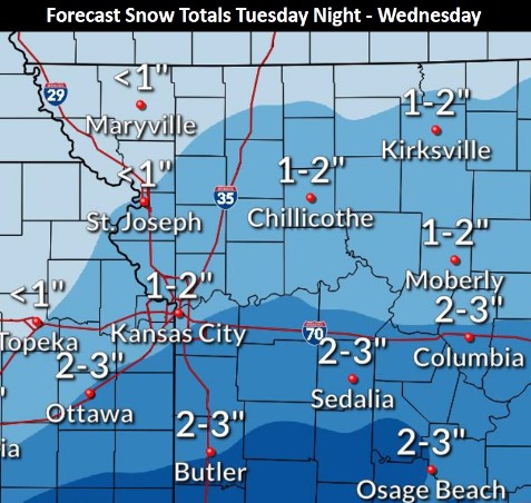
Snow is in the forecast late tonight through Wednesday, the weather service said. Less than one inch of snow is in the forecast for tonight.
Areas to the south of Kansas City may receive 2 to 3 inches of snow.
A winter weather advisory is in effect from 9 p.m. Feb. 16 through 6 p.m. Feb. 17, according to the weather service.
Residents are advised to expect slippery road conditions tonight and Wednesday, that could affect commutes. They are asked to slow down and use caution while traveling.
The latest road conditions are available by calling 511, or by visiting the website, https://www.safetravelusa.com/. The kcscout.net website has highway conditions in the Greater Kansas City area.
Today, Mardi Gras, it will be mostly sunny and cold, with a high near 10, the weather service said. Wind chill values will be between minus 4 and 5. A calm wind will become east southeast around 5 mph in the afternoon.
Tonight, snow is likely, with a 60 percent chance of precipitation mainly after 3 a.m., according to the weather service. The low will be around 4 with wind chill values of between minus 3 and 2, and an east wind of 6 mph. New snow accumulation of less than one inch is in the forecast.
Wednesday, there is a 40 percent chance of snow, mainly before noon, the weather service said. There will be a high near 23 with wind chill values between minus 1 and 9. An east southeast wind will be 5 to 7 mph.
Wednesday night, it will be mostly cloudy, with a low of 7, according to the weather service. The wind chill will be between minus 1 and 4, with a northeast wind of 3 to 6 mph.
Thursday, it will be mostly sunny with a high near 23 and a north wind of 6 to 8 mph, the weather service said.
Thursday night, it will be mostly clear, with a low of 2, according to the weather service.
Friday, it will be mostly sunny, with a high near 32, the weather service said.
Friday night, it will be mostly cloudy, with a low of 19, according to the weather service.
Saturday, it will be partly sunny, with a high near 39, the weather service said.
Saturday night, it will be mostly cloudy, with a low of 31, according to the weather service.
Sunday, it will be partly sunny, with a high near 43, the weather service said.
Sunday night, it will be partly cloudy, with a low of 27, according to the weather service.
Monday, it will be sunny, with a high near 50, the weather service said.
For more weather information, visit www.weather.gov.