Dangerously cold temperatures have descended on Wyandotte County.
The temperature at 11 a.m. Saturday was 14 degrees, with a wind chill of zero, according to the National Weather Service.
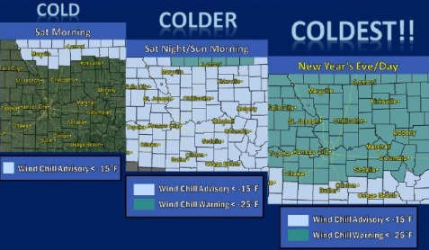
Wyandotte County is under a wind chill advisory from 6 p.m. Dec. 30 until Jan. 1. A wind chill warning will be in effect from midnight Sunday night to noon Monday. Another wind chill advisory will then take effect from noon Monday to noon Tuesday.
The weather service said the cold wind chills will cause frostbite and hypothermia symptoms in as little as 30 minutes. Staying indoors is recommended. If going outside, persons need appropriate clothing and an emergency kit with blankets in their vehicles.
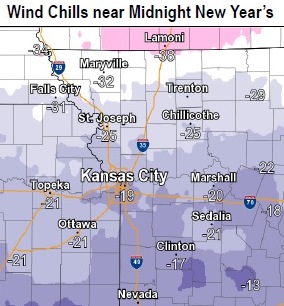
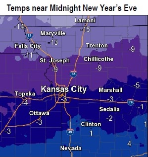
Temperatures will fall into the single digits and wind chill values will plummet from zero to 19 below zero, with the colder wind chills along the Iowa and Missouri border, according to the weather service.
Sunday, temperatures will continue to fall with lows ranging from single digits to 10 below zero near Iowa. Winds will pick up Sunday, dropping wind chill values down to between 10 and 25 below zero with all of the area being under wind chill advisories.
The coldest push of cold air will come New Year’s Eve into New Year’s Day with temperatures dropping between 5 and 20 below early Monday morning and wind chills between 20 and 35 below zero. These wind chill temperatures are extremely dangerous, as frostbite and hypothermia can occur within minutes, the weather service said.
Outside activities should be avoided, according to the weather service. Anyone outside should dress in layers, covering all exposed skin, and they should make sure that other people know their whereabouts.
Today’s Wyandotte County forecast: Mostly sunny and cold, with a high near 11 and wind chill values between minus 5 and zero, the weather service said. The north wind will be 8 to 10 mph.
Tonight, the low will be around minus 1, with wind chill values between minus 4 and minus 13, according to the weather service. A northeast wind will be 8 to 10 mph.
Sunday, it will be mostly sunny and cold, with a high near 5, the weather service said, and a wind chill value of between minus 10 and minus 16. There will be a north wind of 6 to 9 mph.
Sunday night, New Year’s Eve, it will be mostly clear, with a low of minus 9 and wind chill values of between minus 12 and minus 21, according to the weather service. There will be a north wind of 6 to 9 mph.
New Year’s Day, it will be sunny and cold, with a high near 6, the weather service said. There will be a north northwest wind of 5 to 7 mph.
On Monday night, the low will be around minus 9, according to the weather service.
Tuesday, it will be sunny with a high near 18, the weather service said.
Tuesday night, it will be mostly clear with a low of 12, according to the weather service.
Wednesday, it will be mostly sunny with a high near 23, the weather service said.
Wednesday night, the low will be around 4 with mostly clear skies, according to the weather service.
Thursday, it will be mostly sunny with a high near 23, the weather service said.