Severe storms appear to be moving south of the Wyandotte County area today, according to radar maps from the National Weather Service.
Storms currently were south of Ottawa, Kansas, and moving to the east.
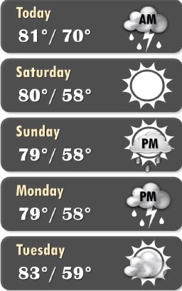
Temperatures were at 74 degrees at 8 a.m., with today’s high near 81, the weather service said. These cool temperatures will stay through the weekend.
A 30 percent chance of rain is still in today’s forecast before 1 p.m., according to the weather service. There will be a north wind of 14 to 20 mph, gusting as high as 28 mph.
Tonight, it will be mostly clear, with a low of 48, according to the weather service. A north northwest wind of 9 to 14 mph will become light west northwest after midnight. Winds may gust up to 21 mph.
Saturday, it will be sunny with a high near 80, the weather service said. A light northwest wind will increase to 5 to 10 mph in the morning.
Saturday night, it will be partly cloudy with a low of 58, according to the weather service, and a west northwest wind of 3 to 6 mph.
Sunday, expect mostly sunny skies with a high near 78, and a northwest wind of 3 to 6 mph, the weather service said.
Sunday night, there is a 20 percent chance of showers with a low of 58, according to the weather service.
Monday, it will be mostly sunny with a high near 79, the weather service said.
Monday night, expect partly cloudy skies with a low of 59, according to the weather service.
Tuesday, it will be mostly sunny with a high near 82, the weather service said.
Tuesday night, there is a 40 percent chance of showers and thunderstorms after 1 a.m., according to the weather service. The low will be around 66.