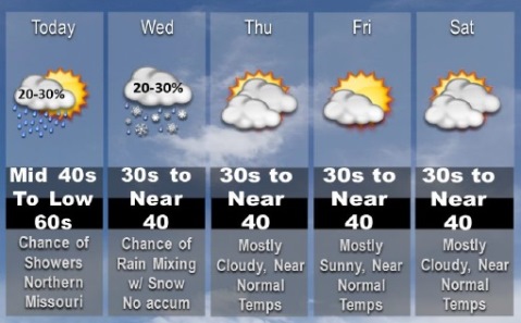
Showers will be possible in some areas today ahead of a cold front, according to the National Weather Service.
In Wyandotte County, the chance of rain is 20 percent after 4 p.m., the weather service said.
After a high of 58 today, the weather will change, with Wednesday’s high near 38, according to the weather service. An east southeast wind of 9 to 17 mph will become south in the afternoon today. Winds could gust as high as 26 mph.
The cooler temperatures will bring a possibility of snow in parts of the region; however, Wyandotte County’s forecast calls only for rain at this time, the weather service said. There is a slight, 20 percent, chance of rain before midnight tonight, with a low of 34 tonight. Winds will be 10 to 13 from the south southwest, changing to west after midnight.
Wednesday, it will be cloudy with a high of 38 and a west northwest wind of 13 to 16 mph, gusting to 24 mph, according to the weather service.
Wednesday night, it will be mostly cloudy with a low of 24, the weather service said. A northwest wind will be 9 to 13 mph, gusting as high as 24 mph.
Thursday, it will be mostly sunny with a high of 37 and a west northwest wind of 8 to 11 mph, according to the weather service.
Thursday night, the low will be around 22, the weather service said.
Friday, it will be sunny with a high near 36, according to the weather service.
Friday night, expect mostly clear skies with a low of 25, the weather service said.
Saturday it will be mostly cloudy with a high of 41, according to the weather service.