After a brief respite from the heat, warm and muggy conditions will return by the early to middle part of next week, according to the National Weather Service.
Today, there will a 30 percent chance of showers and thunderstorms in the morning, the weather service said, with a high near 84. Currently, there are showers to the south and east of Wyandotte County. There will be an east northeast wind of 3 to 6 mph.
Expect heat index values to return to above 100 by Tuesday and persist above 100 through the rest of the week, the weather service said.
There will be a few chances for some isolated to scattered thunderstorms across the northern part of the region through the week, according to the weather service. Higher chances for rain could return by late next week.
Tonight, expect a low of 68 with a light east wind, according to the weather service.
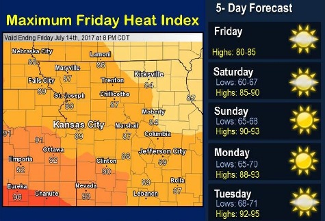
Saturday, it will be sunny with a high near 88 and a calm wind becoming east around 5 mph in the afternoon, the weather service said.
Saturday night, expect a low of 68 with a light and variable wind, according to the weather service.
Sunday, it will be sunny with a high near 91 and a light and variable wind, the weather service said.
Sunday night, the low will be around 69, according to the weather service.
Monday, it will be sunny with a high of 92, the weather service said.
Monday night, the low will be 72 with mostly clear skies, according to the weather service.
Tuesday, there will be sunny skies with a high near 93, the weather service said.