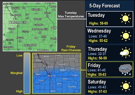
After a frosty start, Tuesday will warm up to a high near 60 degrees, according to the National Weather Service.
Temperatures this week will remain in the 50s and 60s during the day, with overnight lows in the 30s and 40s, the weather service said.
The only chance for rain this week comes on Friday, mainly south of I-70, according to the weather service. Thunderstorms or winter weather is not expected with the precipitation on Friday.
Today, it will be sunny with a high of 60 and a west wind of 5 to 9 mph, the weather service said.
Tonight, it will be mostly clear, with a low of 42, and a west southwest wind around 6 mph becoming light and variable in the evening, according to the weather service.
Wednesday, it will be sunny with a high near 60 and a north wind of 3 to 6 mph, the weather service said.
Wednesday night, it will be clear with a low of 38 and a north northeast wind of 5 mph becoming calm in the evening, according to the weather service.
Thursday, it will be sunny with a high near 59 and a south southeast wind of 3 to 6 mph, the weather service said.
Thursday night, there will be a 40 percent chance of showers after 1 a.m. The low will be 47.
Friday, it will be partly sunny with a high near 62, the weather service said.
Friday night, it will be mostly clear with a low of 43, according to the weather service.
Saturday, it will be sunny with a high near 61, the weather service said.
Saturday night, it will be clear with a low of 40, according to the weather service.
Sunday, it will be sunny with a high near 60, the weather service said.
Sunday night, it will be mostly clear with a low of 46, according to the weather service.
Monday, it will be sunny with a high near 65, the weather service said.