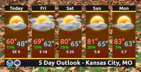
Cool temperatures will remain in place today, before a warming trend returns Friday and through the weekend, according to the National Weather Service.
Rain showers and isolated thunderstorms are possible Friday morning south of the Missouri River, the weather service said.
Better storm chances are possible Saturday night into Sunday, according to the weather service. No severe weather is anticipated at this time.
A frost advisory remains in effect until 10 a.m. this morning. The temperature was 40 degrees at 8 a.m. today, and is expected to reach a high of 59, according to the weather service. There will be mostly sunny skies and an east wind of 3 to 7 mph.
Tonight, there will be mostly cloudy skies with a low of 49, the weather service said. An east southeast wind will be around 5 mph.
Friday’s forecast is mostly cloudy with a high near 70, according to the weather service. The wind will be from the south at 5 to 10 mph.
Friday night, expect a low of 63 with mostly cloudy skies, the weather service said. A south wind of 7 to 10 mph will gust as high as 22 mph.
Saturday, it will be partly sunny with a high near 80, according to the weather service. It will be breezy, with a south wind of 15 to 22 mph, gusting as high as 31 mph.
Saturday night, it will be mostly cloudy with a high near 65, the weather service said.
Sunday will be a mostly sunny day with a high near 82, according to the weather service.
Sunday night, there will be partly cloudy skies with a low of 62, the weather service said.
Monday will be sunny with a high near 83, according to the weather service. Monday night will be mostly clear with a low of 65.