Tuesday started with below freezing temperatures, then warmed to 41 degrees at 9 a.m.
Temperatures should rebound to the seasonal normal by Wednesday, when the high will be 68, according to the forecast. There are no freezing temperatures in the forecast for the next seven days.
According to the National Weather Service forecast, there is a chance of rain on Tuesday night, Wednesday and Thursday.
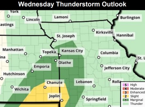
Wednesday could bring a strong thunderstorm in the late afternoon to evening, the weather service said. Stronger severe weather on Wednesday will most likely be to the south of the Kansas City area, near Chanute, Kansas, and Joplin, Missouri. The Kansas City area will be at a marginal risk for severe weather on Wednesday.
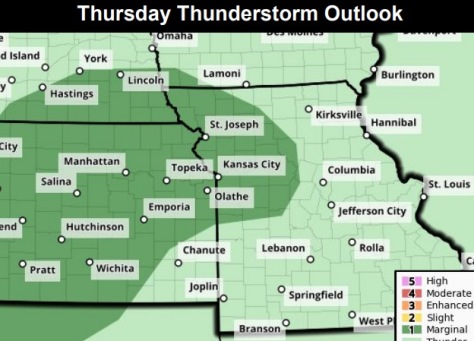
On Thursday, strong thunderstorms are possible Thursday night into Friday, the weather service said. Wyandotte County will be at a marginal risk for severe storms on Thursday.
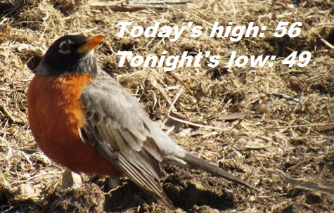
Today, there is a 20 percent chance of showers after 2 p.m., with a high near 56, the weather service said. A south southeast wind of 6 to 14 mph will gust as high as 23 mph.
Tonight, there is a 50 percent chance of showers, with thunderstorms also possible after 4 a.m., according to the weather service. The low will be around 49 with a south southeast wind of 11 to 14 mph, gusting as high as 25 mph. Less than a tenth of an inch of rain is in the forecast.
Wednesday, there is a 70 percent chance of showers and possibly a thunderstorm. The high will be near 68 with a south wind of 13 to 17 mph, gusting as high as 32 mph. Between a quarter and half-inch of rain is possible.
Wednesday night, it will be partly cloudy, with a low of 48 and a west wind of 5 to 7 mph becoming calm in the evening, according to the weather service. Winds may gust up to 20 mph.
Thursday, there is a 30 percent chance of showers, with thunderstorms also possible after 4 p.m., the weather service said. The high will be near 74 with a light east wind becoming east southeast 8 to 13 mph in the morning. Winds may gust as high as 20 mph. Less than a tenth of an inch of rain is expected.
Thursday night, there is a 50 percent chance of showers and thunderstorms, according to the weather service. The low will be around 62. Less than a tenth of an inch of rain is in the forecast.
Friday, it will be partly sunny, with a high of 81, the weather service said.
Friday night, it will be mostly cloudy, with a low of 66, according to the weather service.
Saturday, there is a 50 percent chance of showers after 1 p.m., the weather service said. The high will be near 77.
Saturday night, there is a 70 percent chance of showers and possibly a thunderstorm, according to the weather service. The low will be around 51. It will be breezy.
Sunday, there is a 40 percent chance of showers, with a high near 65, the weather service said.
Sunday night, there is a 30 percent chance of showers, with a low of 44, according to the weather service.
Monday, it will be mostly sunny, with a high near 63, the weather service said.