
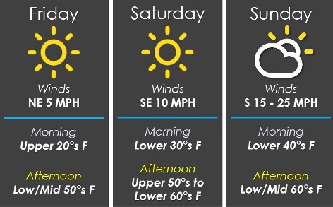
With a freezing start to Friday, temperatures today should reach 54 by 5 p.m., according to the National Weather Service forecast.
The temperature at 8 a.m. was a cold 30 degrees, with a wind chill index of 25, the weather service said.
Temperatures will rise to 59 on Saturday and 64 on Sunday, according to the weather service forecast. Winds will gust up to 30 mph on Sunday.
Rain will be possible Sunday night through Tuesday night, the weather service said.
Today, it will be sunny with a high near 54 and an east northeast wind of 5 to 7 mph, the weather service said.
Tonight, it will be clear, with a low of 31 and an east southeast wind of 3 to 6 mph, according to the weather service.
Saturday, it will be sunny with a high near 59 and a south southeast wind of 5 to 13 mph, gusting as high as 21 mph, the weather service said.
Saturday night, it will be partly cloudy, with a low of 43 and a south southeast wind of 9 to 11 mph, gusting as high as 20 mph, according to the weather service.
Sunday, it will be mostly sunny, with a high near 64 and a south wind of 13 to 20 mph, gusting to 30 mph, the weather service said.
Sunday night, there is a 20 percent chance of rain after 1 a.m., with a low of 48, according to the weather service.
Monday, there is a 70 percent chance of rain, with a high near 59, the weather service said.
Monday night, there is an 80 percent chance of rain, with a low of 49, according to the weather service.
Tuesday, there is a 70 percent chance of rain, with a high near 58, the weather service said.
Tuesday night, there is a 30 percent chance of rain before 1 a.m., with a low of 40, according to the weather service.
Wednesday, it will be mostly sunny, with a high near 58, the weather service said.
Wednesday night, it will be partly cloudy, with a low of 38, according to the weather service.
Thursday, it will be mostly sunny, with a high near 61, the weather service said.