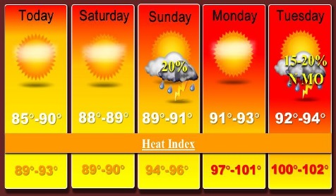
A cold front will dive into the region today, keeping the humidity lower north of the Missouri River, but to the south the heat index will climb into the mid-90s, according to the National Weather Service forecast.
In Wyandotte County, the forecast for today is sunny with a high of 89, and a west wind of 5 to 10 mph becoming north in the morning, the weather service said.
Storm chances will return Sunday afternoon, with the possibility of scattered thunderstorms, according to the weather service.
Higher dewpoints will move into the region Sunday, increasing the heat index values in the mid to upper 90s, with a heat index in the lower 100s possible Monday and Tuesday, the weather service said.
Tonight’s forecast is mostly clear with a low of 67, and a north wind of 5 to 7 mph becoming calm after midnight, according to the weather service.
Saturday, it will be sunny with a high near 88, and a calm wind becoming south southwest around 6 mph in the morning, the weather service said.
Saturday night, look for mostly clear skies with a low of 69, according to the weather service. There will be a south wind of 3 to 5 mph.
Sunday, there will be a 20 percent chance of showers and thunderstorms, the weather service said, with a high near 90.
Sunday night, there will be a 20 percent chance of showers and thunderstorms, before 1 a.m., according to the weather service. The low will be around 73.
Monday, the forecast is sunny skies with a high near 92, the weather service said.
Monday night, expect a low of 75, according to the weather service.
Tuesday, there will be a high near 94 with mostly sunny skies, the weather service said.