Temperatures fell to around 40 degrees overnight, so far the coldest fall temperatures, in Wyandotte County.
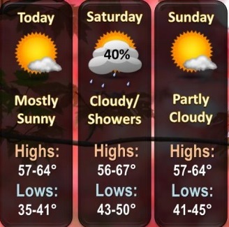
Below normal temperatures are expected through the weekend with highs in the upper 50s to mid 60s and lows in the mid 30s to low 40s this morning and in the 40s on Saturday and Sunday morning, the National Weather Service said.
Today’s high will reach 63, according to the weather service. It was 46 degrees at 9 a.m. Friday.
The weather service also predicted patchy frost in low-lying areas, particularly to the north.
On Saturday morning, there is a 30 percent chance of showers, the weather service said.
Today, it will be sunny with a high near 63 and a calm wind, the weather service said.
Tonight, there is a 30 percent chance of showers after 1 a.m., according to the weather service, with a low of 51 and an east southeast wind of 3 to 8 mph. Less than a tenth of an inch of rain is forecast.
Saturday, it will be partly sunny with a high near 67, the weather service said. An east southeast wind of 6 to 8 mph will become west northwest in the afternoon.
Saturday night, it will be mostly clear with a low around 44 and a light north wind, according to the weather service.
Sunday, it will be sunny with a high near 63 and a north wind of 3 to 8 mph, the weather service said.
Sunday night, it will be clear, with a low around 44, according to the weather service.
Monday, it will be sunny with a high near 73, the weather service said.
Monday night, it will be clear, with a low of 55, according to the weather service.
Tuesday, it will be sunny with a high near 77, the weather service said.
Tuesday night, it will be clear, with a low of 54, according to the weather service.
Wednesday, it will be sunny with a high near 80, the weather service said.
Wednesday night, it will be clear with a low of 51, according to the weather service.
Thursday, it will be sunny, with a high near 78, the weather service said.