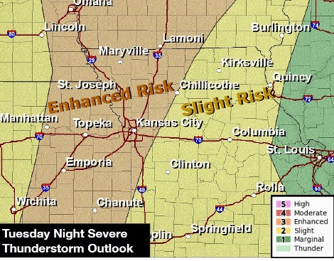
Risk of severe storms Tuesday night
Light rain and scattered showers were possible this morning, according to the National Weather Service forecast.
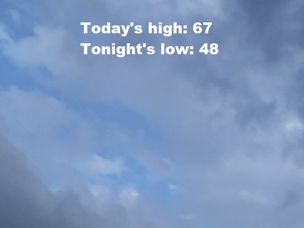
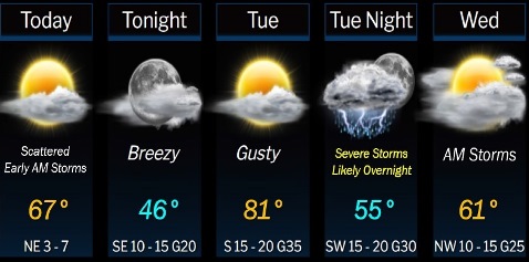
It will be cloudy through mid-morning in Wyandotte County, then gradually clearing, with a high near 67, the weather service said.
On Tuesday night, there will be a line of strong to severe thunderstorms capable of damaging wind gusts, large hail and the potential for isolated tornadoes, according to the weather service. The storms may arrive around 9 p.m. to midnight.
The weather service advised residents to have multiple ways to receive warning information to be alerted late at night if and when warnings are issued.
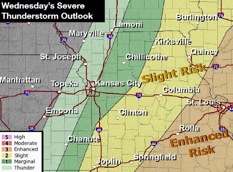
On Wednesday, there also is a chance of thunderstorms and severe storms capable of damaging winds and hail, according to the weather service. Wyandotte County may be at marginal risk. The timing and location are not exact at this time.
Today, look for cloudy skies through mid-morning, then gradually clearing, with a high near 67, the weather service said. An east northeast wind will be around 6 mph.
Tonight, there will be increasing clouds, with a low of 48, according to the weather service. An east southeast wind of 6 to 10 mph will gust as high as 20 mph.
Tuesday, there is a chance of sprinkles before 1 p.m., the weather service said. The high will be near 83 with a south wind of 10 to 15 mph increasing to 16 to 21 mph in the afternoon. Winds may gust as high as 36 mph.
Tuesday night, there is a 50 percent chance of rain and thunderstorms, mainly after 1 a.m., according to the weather service. The low will be around 53 with a south wind of 14 to 21 mph, gusting as high as 33 mph. New rainfall amounts will be less than a tenth of an inch, except higher amounts are possible in thunderstorms.
Wednesday, there is a 30 percent chance of rain and storms before 1 p.m., with a high near 63, the weather service said. A southwest wind of 10 to 17 mph will become west northwest in the afternoon. Winds may gust as high as 25 mph. New rainfall amounts will be less than a tenth of an inch.
Wednesday night, it will be partly cloudy, with a low of 35, according to the weather service.
Thursday, it will be sunny, with a high near 58, the weather service said.
Thursday night, it will be mostly clear, with a low of 37, according to the weather service.
Friday, it will be partly sunny, with a high near 65, the weather service said.
Friday night, it will be partly cloudy, with a low of 42, according to the weather service.
Saturday, it will be partly sunny, with a high near 62, the weather service said.
Saturday night, there is 30 percent chance of precipitation, with a low of 44, according to the weather service.
Sunday, there is a 30 percent chance of rain, with a high near 60, the weather service said.