There will be a chance of frost tonight, as temperatures may drop to the low 30s, according to the National Weather Service.
It’s more likely that areas north of the Missouri River will drop to freezing, while Wyandotte County may stay a couple degrees above freezing, according to the forecast.
Any sensitive vegetation should be protected tonight, the weather service said.
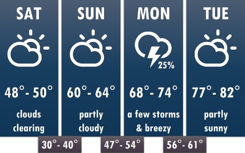
The temperature was in the mid-40s at 4 p.m. Saturday. Sunday’s high will be around 62. Temperatures could rise to the 80s on Monday.
A few storms are possible on Monday, but severe weather is not expected.
Tonight, the low will be around 34, with areas of frost possible after 2 a.m., according to the weather service. There will be an east northeast wind of 6 mph becoming calm in the evening.
Sunday, there may be areas of frost before 8 a.m., with the day’s high of 62 in the afternoon. Winds will become south southeast 5 to 9 mph in the morning.
Sunday night, there is a 20 percent chance of showers after 1 a.m., with a low of 52, according to the weather service.
Monday, there is a slight, 20 percent, chance of showers and thunderstorms before 1 p.m., with a high near 72, the weather service said. A south southwest wind of 7 to 13 mph will gust as high as 28 mph.
Monday night, there is a low of 61 with a south southwest wind of 7 to 9 mph, gusting as high as 20 mph, according to the weather service.
Tuesday, it will be mostly sunny, with a high near 81, the weather service said.