Weather clears today; more storms possible later in week

National Weather Service graphic

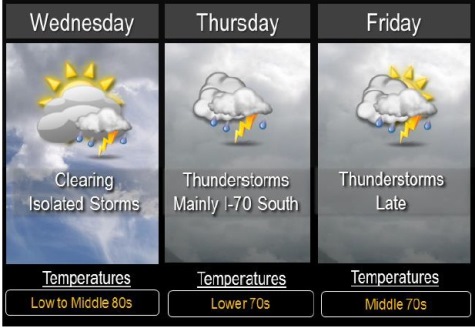
Wednesday’s weather will be clearing, mostly sunny with a high near 87, after overnight storms.

Winds on Wednesday may gust as high as 18 mph, the National Weather Service said.

Isolated storms are possible this afternoon to the south of I-70. Any storm that develops could become strong with gusty winds and hail, but most areas will remain dry, the weather service said.

Thunderstorms return to the forecast for the region from Thursday through Sunday, but not all of them will necessarily be in Wyandotte County.

Numerous thunderstorms are expected Thursday mainly from near I-70 southward.

Any severe thunderstorms are expected to stay south of a Paola to Clinton line where large hail and gusty winds are possible.

Additional thunderstorms are possible Friday and Friday night and could again be strong and produce heavy rain across much of the area.

These numerous rounds of thunderstorms could bring additional flooding to the region through the end of the week.

UG to look at convention center for Village West area

The Unified Government is considering a feasibility study for a convention center in or near Village West in western Kansas City, Kan.

At an Economic Development and Finance Standing Committee meeting Monday night, UG Administrator Doug Bach received preliminary approval to send out a request for proposals for a feasibility study for convention space in or near Village West and the entire I-435 corridor in western Wyandotte County.

The feasibility study idea will go before the June 5 UG Commission meeting for commission approval. It was unanimously approved by the committee.

Bach told the committee that during the last few years, developers had approached the UG about convention space. There were different proposals, but the UG staff believed the UG ought to “take control of it” and make sure the project is done for the long-term benefit of the community, and not for the benefit of the development itself, Bach told the committee.

He said there have been conversations with different parties, including the Hollywood Casino-Kansas Speedway group, which is moving forward on a hotel with 250 rooms currently. The hotel is scheduled to be constructed in October.

Bach said the UG also has been talking with the Convention and Visitors Bureau of Kansas City, Kan., about a convention center.

He recommended that the UG do its own RFP, select a consultant to do an analysis to see if a convention center is feasible, and if so, how big should it be and what would be the best location, and not take the project to one developer.

He told the UG committee that the majority of the $50,000 approximate study cost might be funded by other entities, although the UG would be in control of it. He said the CVB and the casino group might contribute to paying for most of the study. The study may take 60 to 90 days.

If the study recommends a convention center site next to the casino hotel, there might be an extension of the time the casino group is allowed to start building the hotel, especially if the hotel needs to be relocated, Bach said. However, the site of the convention center could be anywhere along the I-435 corridor.

“I think this is a great time to proceed with studying this,” said Commissioner Jim Walters. “There’s a lot of interest.”

He said he recently attended a commissioners’ conference in Manhattan, Kan., which had a better convention facility than did Kansas City, Kan. One day at the conference, the spouses took a side trip to go shopping at The Legends in Kansas City, Kan., he related.

Commissioner Ann Murguia asked Bach to come back to the UG Commission for further approval if the funds the UG would have to pay for the study were a lot larger than anticipated.

Commissioner Gayle Townsend said this benefits the UG from the planning perspective, as it puts the UG in a position of strength and knowledge, and it sounded like a reasonable project.
Severe thunderstorms possible today

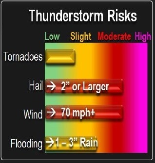
Thunderstorm risks. National Weather Service graphic

Scattered thunderstorms may form over eastern Kansas and western Missouri early Tuesday afternoon, according to the National Weather Service.

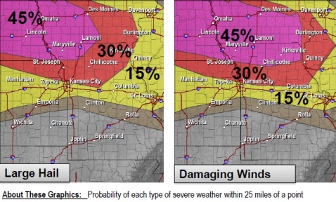
Given increasing instability across the region, these storms could quickly become severe, with large hail and damaging winds. Forecasters are not yet sure about the severe weather, however.

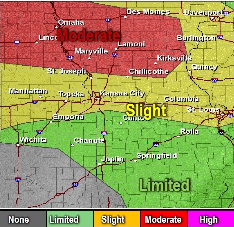
Thunderstorms are expected to develop over northern Kansas by mid-afternoon Tuesday. One National Weather Service map shows the Kansas City area under a slight risk for thunderstorms. The storms could move to the east and southeast. They have the potential to produce widespread wind damage, along with heavy rain and a few tornadoes.

The areas most likely to see these storms are to the north of U.S. Highway 36 (around St. Joseph, Mo.). However, there is a chance these storms could spread further south toward I-70 where the environment also will be favorable for severe storms and heavy rainfall, according to the weather service.

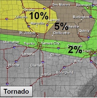
The primary risks early in the event will be very large hail, localized damaging winds, and even a few tornadoes. As the evening progresses, the damaging wind and flash flooding risk will increase greatly, the weather service said.

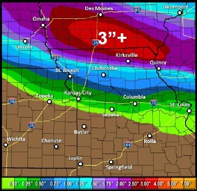
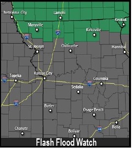
Heavy rainfall is expected to fall across far northern Missouri and southern Iowa, leading to areas of flash flooding across far northern Missouri Tuesday night, followed by minor river flooding later in the week.

Several rounds of thunderstorms are possible Thursday into the weekend, the weather service said. These could be strong to severe and may produce heavy rainfall, especially Friday and Saturday afternoon and night. The potential for multiple rounds of thunderstorms will lead to an elevated flooding risk later this week, according to the weather service.

For updates, visit www.weather.gov.

Tornado risks Tuesday. National Weather Service graphic

Thunderstorm risks. National Weather Service graphic

Risk of large hail and damaging winds Tuesday. National Weather Service graphic

Expected rainfall amounts. National Weather Service graphic

Flash flooding risk. National Weather Service graphic