Storm moves into Wyandotte County

Rain was falling at I-70 and I-635 in Kansas City, Kan., on Thursday morning. (KC Scout photo)

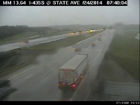
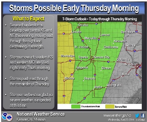
A storm has moved into the Wyandotte County area on Thursday morning.

The storms on Thursday are not expected to be severe but will lead to a wet morning commute, the National Weather Service said.

A long north-south line of storms reaches from north of Topeka to Chanute, Kan., and Neosho, Mo., and is moving toward this area.

Today’s forecast includes an 80 percent chance of showers. Thunderstorms are possible before noon, then another chance of showers and storms between noon and 4 p.m. There will be a slight chance of showers after 4 pm. Then, there is a slight chance of showers befrore 7 p.m.
South winds of 11 to 16 mph will change to the northwest in the afternoon, gusting as high as 24 mph.
Friday’s forecast will be sunny with a high of 79.
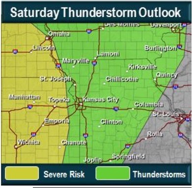
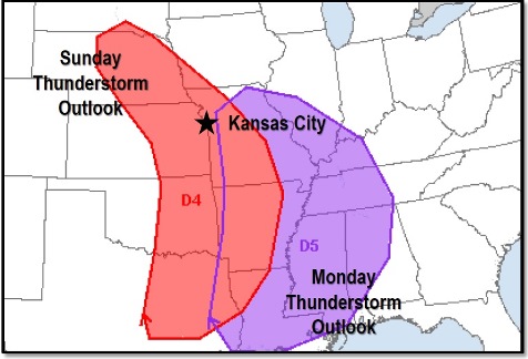
Then, there is a 20 percent chance of storms on Friday night, 30 percent chance of storms on Saturday, 40 percent chance of storms on Saturday night, 60 percent chance of storms Sunday and Sunday night, and 30 percent chance of storms Monday.

The round of thunderstorms later Saturday and overnight Saturday has a low possibility of severe weather, according to the weather service.

A more significant series of severe thunderstorms is expected to occur Sunday and Monday, the weather service said. On Sunday, the main threat will be eastern Kansas and western Missouri, shifting east on Monday to western Missouri and east of it. Large hail, damaging winds and tornadoes are all possible on Sunday and Monday, the weather service said.

Motorists drove over the Missouri River on I-635 into Kansas City, Kan., on Thursday morning, as rain fell. (KC Scout photo)
Heavy rain was falling Thursday morning on I-435 south of State Avenue in Wyandotte County. (KC Scout photo)
National Weather Service graphic


On Sunday and Monday, severe thunderstorms are predicted in the Kansas City area. (National Weather Service graphic)

Rain in today’s forecast

National Weather Service graphic

Rain is in the forecast for Wednesday and Thursday.

A 30 percent chance of rain today will increase overnight to 80 percent.

Today’s high will be near 77, and winds will begin to pick up. Winds of 11 to 21 mph from the southeast could gust to as high as 30 mph, according to the National Weather Service.

The likelihood of rain and storms increases after 4 a.m. Thursday. Between a tenth and quarter of an inch, with higher amounts in storms, is possible.

Some strong thunderstorms are possible Thursday orning as a cold front sweeps through the area. They are likely to start before sunrise, and small hail and strong winds are possible.

Showers and thunderstorms may continue Thursday before 1 p.m. The high will be near 70. Winds may gust as high as 23 mph.

The weather clears Thursday night, and Friday’s forecast is sunny with a high near 77. Winds could gust as high as 23.

On Saturday, Saturday night and Sunday, the chance of showers and thunderstorms returns. A chance of rain also is in the forecast for Monday and Tuesday. There is a potential for severe storms Sunday and Monday.

National Weather Service graphic


Sunny spring day ahead

Skies are sunny and temperatures will reach 70 degrees today, according to the National Weather Service. A northeast wind of 6 to 8 mph is in today’s forecast.

Wednesday, temperatures will climb to 76 and winds will pick up to 9 to 14 mph in the morning and 17 to 22 mph in the afternoon, gusting to 30 mph.

The beautiful spring weather will last until Wednesday night, when showers and thunderstorms are possible after 1 a.m.  The chance of rain is 80 percent.

Thursday, there will be a 50 percent chance of showers and storms before 1 p.m.

Friday’s forecast is mostly sunny and a high near 75.

Saturday, there is a chance of showers and storms, with a high near 67. The chance of rain is 40 percent.

Sunday’s forecast also calls for a chance of showers and storms, with a high near 67.