Rain showers and cool weather are in the forecast for Tuesday, according to the National Weather Service.
A 70 percent chance of showers is possible. Today’s high will be near 52. A west northwest wind will be from 10 to 16 mph, with gusts as high as 24 mph.
Tonight, there is a 50 percent chance of showers, and the low will be 40.
Wednesday, the chance of showers decreases to 30 percent, and rain is likely mainly after 1 p.m. The high will be near 53, with windy weather.
Thursday, it will be mostly cloudy with a high of 56. Friday’s high will be 63 and Saturday’s, 68.
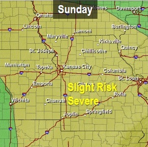
Severe storms possible Sunday. (National Weather Service graphic)
Showers and thunderstorms are possible before noon Saturday.
Some may produce small hail, according to the National Weather Service. The storms Saturday morning are not expected to be severe.
Tonight and Sunday, a powerful storm system will move into the area.
Two or three rounds of thunderstorms are possible, beginning as early as sunrise Sunday and lasting into Sunday evening.
The potential exists for strong to severe thunderstorms through the day Sunday with large hail, damaging winds and a few tornadoes.
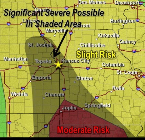
Significant severe weather, including large hail and strong tornadoes, is possible, but this is still uncertain, the weather service said.
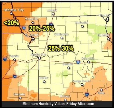
Elevated fire danger Friday afternoon. (National Weather Service graphic)
Sunny and clear weather for Friday may be followed by a chance of showers and thunderstorms on Saturday, Sunday and Monday, according to the National Weather Service.
Today’s high will be 79, and the wind will be 6 to 15 mph, with gusts up to 21 mph. There is an elevated fire danger this afternoon because of the wind and low humidity, although recent rains will prevent a widespread threat for significant fires.
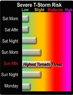
Multiple rounds of strong to severe thunderstorms are possible this weekend, the National Weather Service said.
Saturday’s weather will include a 30 percent chance of showers and thunderstorms between 4 a.m. and 1 p.m. Winds will be 10 to 18 mph changing from south to east in the morning. Winds may gust as high as 28 mph. The temperature will be 85 on Saturday.
Severe thunderstorm risk (National Weather Service graphic)
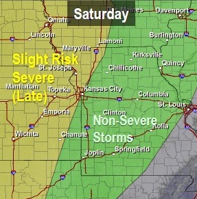
The storms early Saturday will include the possibility of small hail. After a break in the weather Saturday afternoon, several rounds of strong to severe storms are expected late Saturday night through Sunday night.
Risk of severe weather Saturday. (National Weather Service graphic)
Strong extreme wind shear and moderate to high instability on Sunday will be favorable for multiple tornadoes, very large hail and potentially widespread damaging winds, according to the weather service. The highest chances for severe storms will be late Sunday afternoon and early evening.
On Saturday night, the chance of storms increases to 40 percent, and will be 70 percent Sunday, according to the forecast.
Risk of severe storms on Sunday. (National Weather Service graphic)
Monday will be mostly sunny, but Monday night will have a 30 percent chance of showers and Tuesday, a 50 percent chance of showers.
For more weather information, visit www.weather.gov.