Rain, storms likely today

National Weather Service graphic
Showers were moving through Wyandotte County around 7:20 a.m. Thursday, May 22.

The National Weather Service said showers and storms are likely before 11 a.m. Thursday. Today’s temperatures will reach a high of around 78.

Tonight’s forecast also has a 50 percent chance of showers and storms, with a low around 62.

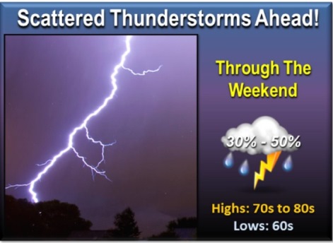
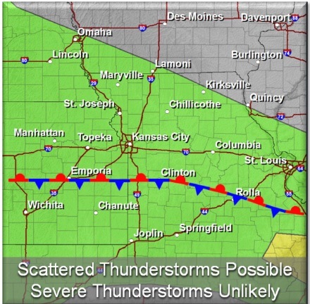
The National Weather Service said a stalled frontal boundary, combined with a system lingering over the southwestern part of the United States, will keep a persistent chance for storms in the region the rest of the week and into the Memorial Day weekend. The storms will likely be scattered, but strong storms cannot be entirely ruled out.

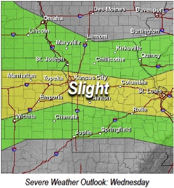
Today, thunderstorms will move into northeast Kansas with the strongest storms able to support some small hail. Further development of storms may occur this afternoon along a stalled front boundary, from central Kansas to central Missouri, with marginally severe hail possible.

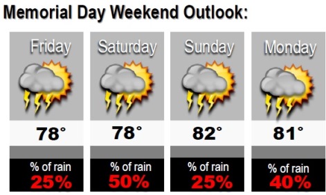
On Friday, there will be a 40 percent chance of showers and thunderstorms, with a high near 79.

Friday night, look for a 50 percent chance of showers and storms, with a low around 65.

On Saturday, showers and thunderstorms are likely, with a high near 78.

Rain continues in the forecast through Tuesday.

Chance of storms Wednesday evening through weekend

National Weather Service graphic
There will be low chances for thunderstorms each day heading into the weekend, according to the National Weather Service forecast.

The storms likely will be scattered in nature, but given the persistent warm and humid conditions, strong to even severe storms can’t be ruled out. Today, a few strong to severe storms are possible, and a slight risk for storms is in place for a narrow corridor along I-70.

The primary risks are damaging downburst winds along with large hail.

There is a 20 percent chance of storms from 4 p.m. to 10 p.m. Wednesday. The risks include downburst winds, large hail and localized heavy rain.

After 10 p.m. Wednesday, there is a 50 percent chance of showers and storms.

Thursday, there is a 40 percent chance of rain, with a high near 81. Thursday night, there is a 50 percent chance of showers and thunderstorms.

For Memorial Day weekend, the weather outlook is 78 degrees on Friday with a 25 percent chance of rain; 78 degrees Saturday with a 50 percent chance of rain; 82 degrees Sunday with a 25 percent chance of rain; and 81 degrees Monday with a 40 percent chance of rain.

National Weather Service graphic

National Weather Service graphic

Skies to be mostly sunny today

Skies will be mostly sunny Friday with a high near 72. The wind will be from the west at 7 to 10 mph.

Tonight, skies will be partly cloudy with a low around 57, the weather service said. The wind will be west southwest around 8 mph, becoming south southeast after midnight.

Saturday, there is a chance of showers and thunderstorms after 1 p.m. The weather will be mostly sunny with a high near 83, according to the weather service. The south wind will be from 9 to 13 mph. The chance of precipitation is 30 percent.

For Saturday night, the forecast is a 50 percent chance of showers and storms. The weather will be mostly cloudy with a low around 63, the weather service said. Winds will be 6 to 11 mph becoming northeast after midnight. Between a quarter and a half-inch of rain is possible.

On Sunday, there is a 50 percent chance of showers and storms, and weather is mostly cloudy with a low around 79. The wind may gust as high as 28 mph.

Sunday night, showers and thunderstorms are likely, according to the weather service. The weather is mostly cloudy with a low around 60. There is a 60 percent chance of precipitation.

Monday’s forecast is a 60 percent chance of showers and thunderstorms. Skies are mostly cloudy with a high near 70.

For more weather information, see www.weather.gov.