National Weather Service graphic
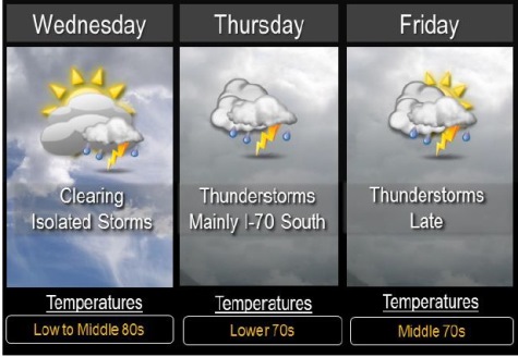
Wednesday’s weather will be clearing, mostly sunny with a high near 87, after overnight storms.
Winds on Wednesday may gust as high as 18 mph, the National Weather Service said.
Isolated storms are possible this afternoon to the south of I-70. Any storm that develops could become strong with gusty winds and hail, but most areas will remain dry, the weather service said.
Thunderstorms return to the forecast for the region from Thursday through Sunday, but not all of them will necessarily be in Wyandotte County.
Numerous thunderstorms are expected Thursday mainly from near I-70 southward.
Any severe thunderstorms are expected to stay south of a Paola to Clinton line where large hail and gusty winds are possible.
Additional thunderstorms are possible Friday and Friday night and could again be strong and produce heavy rain across much of the area.
These numerous rounds of thunderstorms could bring additional flooding to the region through the end of the week.
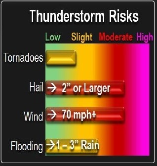
Thunderstorm risks. National Weather Service graphic
Scattered thunderstorms may form over eastern Kansas and western Missouri early Tuesday afternoon, according to the National Weather Service.
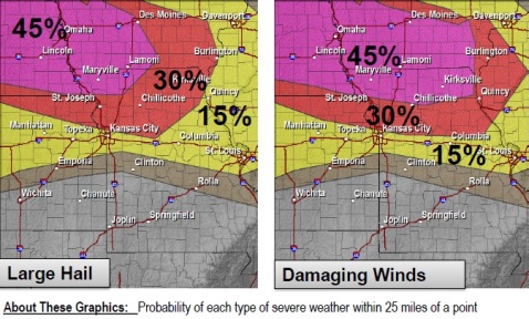
Given increasing instability across the region, these storms could quickly become severe, with large hail and damaging winds. Forecasters are not yet sure about the severe weather, however.
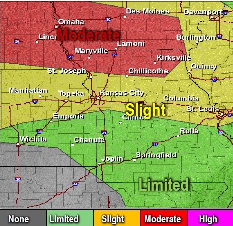
Thunderstorms are expected to develop over northern Kansas by mid-afternoon Tuesday. One National Weather Service map shows the Kansas City area under a slight risk for thunderstorms. The storms could move to the east and southeast. They have the potential to produce widespread wind damage, along with heavy rain and a few tornadoes.
The areas most likely to see these storms are to the north of U.S. Highway 36 (around St. Joseph, Mo.). However, there is a chance these storms could spread further south toward I-70 where the environment also will be favorable for severe storms and heavy rainfall, according to the weather service.
The primary risks early in the event will be very large hail, localized damaging winds, and even a few tornadoes. As the evening progresses, the damaging wind and flash flooding risk will increase greatly, the weather service said.
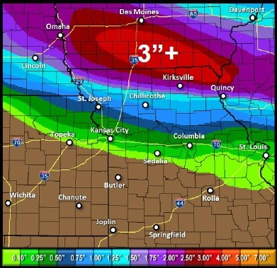
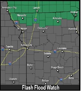
Heavy rainfall is expected to fall across far northern Missouri and southern Iowa, leading to areas of flash flooding across far northern Missouri Tuesday night, followed by minor river flooding later in the week.
Several rounds of thunderstorms are possible Thursday into the weekend, the weather service said. These could be strong to severe and may produce heavy rainfall, especially Friday and Saturday afternoon and night. The potential for multiple rounds of thunderstorms will lead to an elevated flooding risk later this week, according to the weather service.
For updates, visit www.weather.gov.
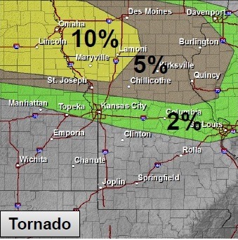
Tornado risks Tuesday. National Weather Service graphic Thunderstorm risks. National Weather Service graphic Risk of large hail and damaging winds Tuesday. National Weather Service graphic Expected rainfall amounts. National Weather Service graphic Flash flooding risk. National Weather Service graphic
Scattered thunderstorms possible (National Weather Service graphic)
Scattered thunderstorms are possible Friday, according to the National Weather Service.
A stalled frontal boundary across southern Missouri, combined with a system lingering over the southwestern United States, will keep a persistent chance for thunderstorms in the region each of the days through the Memorial Day weekend.
These storms likely will be scattered in nature, but given the persistent warm and humid conditions, strong to even severe storms can’t be ruled out.
An outflow boundary from morning storms may allow redevelopment later this afternoon along a line from Wichita to Clinton and Rolla. This corridor has the highest potential for strong to severe storms later today. Further north, elevated storms may pulse up and down but will remain under severe limits.
Non-severe storms are anticipated into this weekend, with the highest potential tonight through midday Saturday. Rain will be scattered in nature, and not all areas will see rain, according to the weather service.
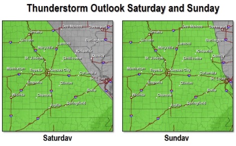
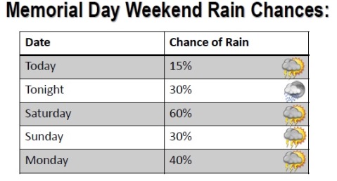
Friday’s high will be 78, with a 20 percent chance of rain. Saturday, the high will be 77, with a 60 percent chance of storms. Sunday, the high will be 82 with a 40 percent chance of storms, and Monday, Memorial Day, the temperature will reach 82 with a 40 percent chance of storms. Thunderstorm outlook Saturday and Sunday (National Weather Service graphic) Memorial Day weekend rain chances (National Weather Service graphic)