Flood advisory in effect for Wyandotte County

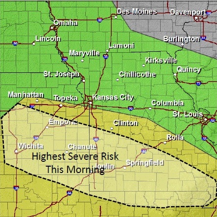
A flood advisory is in effect for Wyandotte County until 9:30 p.m. Tuesday.

At 9:26 a.m. Tuesday, runoff from earlier heavy rainfall ranging from 2 to 3 inches continued to produce minor flooding across the advisory area, the National Weather Service stated.

Periods of rain are expected to continue this morning with only light additional accumulations expected.

Bonner Springs, Kansas City, Kan., downtown Kansas City, Mo., and many surrounding areas are in the area that will experience minor flooding, the weather service said.

Residents are warned not to drive their vehicles into areas where the water covers the roadway. The water depth may be too great to allow a car to cross safely, the weather service stated.

The Missouri and Kansas rivers at Kansas City, Kan., were well below flood stage at 10 a.m. Tuesday, according to hydrology charts. Turkey Creek at Southwest Boulevard was 50 feet at 10:28 a.m.; flood stage there is 61 feet.

Storms possible Saturday

Friday storm risk. National Weather Service graphic

While there is a 30 percent of showers and storms this afternoon, storms are more likely tonight and Saturday, according to the National Weather Service.

The chance of storms increases to 70 percent tonight, mainly after 1 a.m., and then to 90 percent on Saturday. However, the worst of the storms may be south of the Kansas City area.

Friday’s high is expected to be 83 degrees, with winds of around 7 mph.

The National Weather Service stated that the threat of severe thunderstorms looks to be very low at this time for far eastern Kansas and northern Missouri on Saturday, and is focused in areas to the west and south, particularly central Kansas into southern Missouri.

Storms are possible tonight through Tuesday, the weather service said. Some of this activity could produce torrential rain, which would lead to additional flooding across the area.

Rainfall could top 2 to 4 inches through the weekend in the region and could lead to flooding, the weather service said.

Tonight’s severe weather probabilities. National Weather Service graphic

Saturday and Sunday severe weather risk. National Weather Service graphic

Rain potential through next week. National Weather Service graphic

Severe thunderstorm watch in effect

National Weather Service graphic

A severe thunderstorm watch is in effect from 8:05 a.m. until 2 p.m. June 5 in Wyandotte County.

A cluster of severe storms will continue to move eastward across Kansas this morning, the National Weather Service said.

The strongest activity will continue east and take a southeastern turn as it reaches eastern Kansas with the highest risk for severe storms along a line from Paola to Clinton. The main risk will be damaging winds.

This storm has a risk of heavy rain and brief gusty winds. The storm is expected to be at its strongest in the morning on Thursday. Today’s high will be 77 degrees.

Additional thunderstorms are possible Thursday night, Friday and Friday night as well as on Saturday, according to the weather service. All the activity could become strong and produce heavy rain and additional flooding across much of the area.

Additional rainfall through this weekend may top 2 to 4 inches across the local area. This heavy rainfall, on top of already saturated grounds, could lead to additional flooding into early next week.

Hail risk (National Weather Service graphic)

Wind risk (National Weather Service graphic)

Rain potential through Saturday (National Weather Service graphic)