Heat index could reach nearly 100 degrees today

National Weather Service graphic

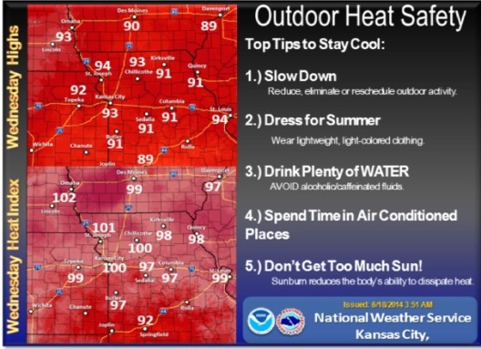
The heat index may hit the upper 90s and lower 100s today in Wyandotte County.

At 9 a.m., temperatures were 82 with a heat index of 86. At 3 p.m. today, the National Weather Service predicts a temperature of 91 degrees with a heat index of 98.

Hot and humid conditions mean that residents should take precautions for the heat.

Some advice from the National Weather Service:
• Slow down; reduce, eliminate or reschedule outdoor activity.
• Dress for summer; wear lightweight, light-colored clothes.
• Drink plenty of water; avoid alcohol and caffeinated fluids.
• Spend time in air-conditioned places.
• Don’t get too much sun; sunburn reduces the body’s ability to dissipate heat.

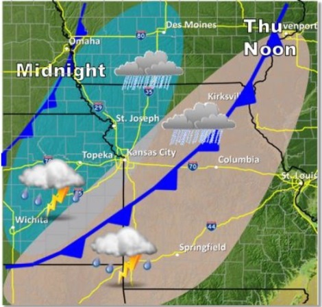
A complex of thunderstorms could develop north of the Kansas City area tonight, according to the weather service. There is a 20 percent chance of severe thunderstorms here. The storm also could bring damaging winds and small hail along and north of the Highway 36 corridor, near St. Joseph, Mo., after midnight.

There is also a 50 percent chance for isolated severe storms north of a Kirksville, Mo., to Kansas City line on Thursday, according to the weather service. These storms could bring large hail and damaging winds.

Rain hits Wyandotte County

Motorists made their way to work in the rain about 7 a.m. Thursday on I-70 near 86th Street. (KC Scout photo)

A large area of showers and thunderstorms will gradually weaken as it spreads from Kansas and west central Missouri towards central Missouri this morning.

The National Weather Service said no severe weather is anticipated today. However, heavy rains up to an inch plus small hail were possible from the Kansas City area southward.

Much of the rain has already fallen early this morning in Kansas City, and rain was expected to be over by 11 a.m.

The rain caused several accidents in the Kansas City area. One was at I-635 and I-35, about 7:08 a.m.

The heaviest rains were along and south of I-70 with local amounts over an inch possible.

At 8 a.m., K-5 in Leavenworth County was closed to all traffic at Seven-Mile Creek. Flood waters were over the roadway, and motorists were asked to use alternate routes.

While widespread flooding is not expected, minor flooding is likely in those areas that are prone to excessive runoff and low water crossing areas, according to the weather service. The Kansas and Missouri rivers were well below flood stage at 7 a.m. Thursday.

Today’s high temperature will be 75 degrees.

Friday’s forecast is sunny and 77. Saturday, temperatures will be near 86 with mostly sunny skies.

The rain returns to the forecast with a 50 percent chance of showers and storms Saturday night. There is a 60 percent chance of thunderstorms on Sunday. Showers and thunderstorms remain in the forecast for Monday, Tuesday and Wednesday.

Severe weather outlook Thursday. (National Weather Service graphic)

Thursday rainfall. (National Weather Service graphic)

Water levels at Turkey Creek at Southwest Boulevard. (NOAA graphic)

Clear today; rain possible Thursday

National Weather Service graphic

Today’s forecast is sunny with a high of 82.

Look for the chance of rain to return overnight, as a cold front tracks east through Kansas and Missouri on Thursday, according to the National Weather Service forecast.

A 50 percent chance of thunderstorms and rain is possible after 1 a.m. A quarter to a half-inch of rain is possible. Showers and storms will be more numerous south of I-70, according to the weather service. The heaviest rains may be south of Kansas City.

On Thursday, there will be a 40 percent chance of thunderstorms and rain. Between a tenth and a quarter of an inch of rain is in the forecast.