A severe thunderstorm watch is in effect for Wyandotte, Leavenworth and Johnson counties until 1 a.m. July 8, according to the National Weather Service.
At 9 p.m., weather service radar showed a major storm to the north of the Kansas City area, near St. Joseph, Mo.
The radar map also showed a second group of storm clouds west of Topeka.
For the latest weather information, visit www.weather.gov.
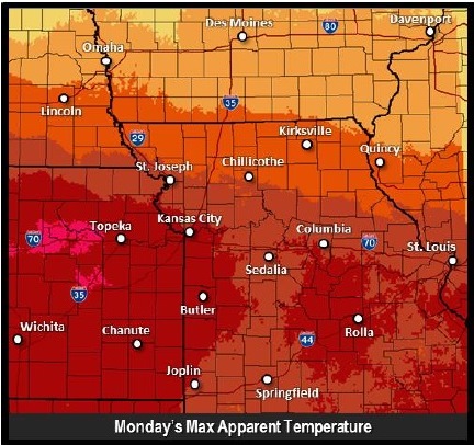
Monday temperatures. National Weather Service graphic
High heat, storms and flash flooding are in the forecast for Monday from the National Weather Service.
Today’s temperatures will be a high near 94, with a heat index as high as 101, the weather service said.
The temperature at 10 a.m. was 81 degrees with a heat index of 84.
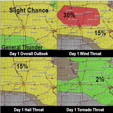
The weather service said hot and humid conditions along with an arriving cold front from the north will lead to severe thunderstorms early this evening.
The main concerns will be strong damaging winds with the greatest threat found in northeast Kansas and northern Missouri, the weather service said. Severe hail also is possible with any storms that develop later this evening and overnight.
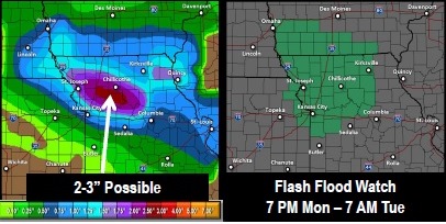
The severe weather threat possibly may result in heavy rain and possible flash flooding overnight as the cold front slowly sinks south across the area.
As this occurs, strong winds in the lower atmosphere may pump ample amounts of low-level moisture north. The end result could be heavy rains with the possibility of flash flooding, according to the weather service.
A flash flood watch is in effect for Wyandotte County and surrounding areas from 7 p.m. Monday until 7 a.m. Tuesday, the weather service said.
For up-to-date weather information, visit www.weather.gov. Severe storms possible. National Weather Service graphic Heavy rain, flash flooding possible
It will be a nearly perfect day for weather in Wyandotte County.
Today’s high will be 80 degrees and the skies will be sunny, according to the National Weather Service.
Tonight, mostly clear weather with a low of 61 in in the forecast.
For Friday, the Fourth of July, the forecast is sunny with a high near 84.
Evening hours are expected to be clear. There’s a 40 percent chance of showers and thunderstorms late Friday night, after 1 a.m., according to the weather service.
Saturday’s forecast has a 40 percent chance of thunderstorms, and a high of 87 is predicted.
Sunday, skies will be mostly sunny and the high will be around 92.