Storm moves through area

Storm clouds have moved through the Kansas City area this morning and are now located to the east.

National Weather Service graphic
The Kansas City area experienced heavy rains on Wednesday night, and some residents reported downed tree limbs.

The Board of Public Utilities at 8 a.m. Thursday reported 423 customers affected by power outages, according to the outage map, with 325 without power at 8 a.m. The outage locations were scattered throughout Kansas City, Kan.

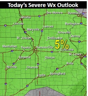
There is slight chance for showers through 11 a.m. Thursday, according to the National Weather Service forecast, and a few storms may develop in the late afternoon and early evening across central and south-central Missouri. Strong winds would be the greatest threat for any storms.

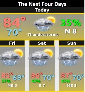
The threat for showers and storms will continue into the weekend as the frontal boundary remains in close proximity to the area, the weather service said. The threat for widespread severe weather remains low.

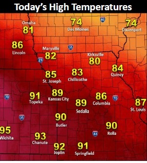
Today’s high should be near 83.

Wyandotte County under flood advisory

Wyandotte County is under an urban and small stream flood advisory that started at 9:23 p.m. Aug. 6 and continues until 12:30 a.m. Aug. 7, according to the National Weather Service.

Other nearby counties, including Leavenworth and Atchison counties, also are under this flood advisory.

Doppler radar estimated between 2 and 4 inches of rain fell during the previous three hours, with more heavy rain expected during the next few hours. An additional 1 to 2 inches of rain will be possible during the next couple of hours.

Runoff from this excessive rainfall will cause minor flooding, especially along small streams and near low water crossings, the weather service said. Bonner Springs, Edwardsville and Kansas City, Kan., are expected to have some areas that experience minor flooding.

Cold front to bring relief from heat on Thursday

National Weather Service graphic

Showers and thunderstorms are in today’s forecast, mainly after 4 p.m.

The National Weather Service said today’s high will be near 89. The chance of rain is 60 percent.

Storms at 8 a.m. were located in Nebraska, to the north of the Kansas City area.

The cold front and storms moving through the area are not expected to result in severe weather. For any storms that do approach severe storms, isolated large hail and sporadic strong winds will be the main concerns, the weather service said.

Showers and storms then will remain in the forecast through much of the remainder of the week. Weak wind fields aloft should limit the overall severe weather threat, but stray severe storms cannot be ruled out Thursday and Friday, according to the weather service.

Temperatures through the period will return to below normal limits by Thursday, as highs only warm into the upper 70s to mid-80s.

National Weather Service graphic