Heat advisory in effect today

National Weather Service graphic

A heat advisory is in effect in Wyandotte County until 8 p.m. Saturday, Aug. 23, according to the National Weather Service.

Temperatures at 2 p.m. were 96 degrees here, with a heat index of 101.

Today’s high this afternoon may reach 98, with a heat index as high as 101. A south wind will be around 11 mph.

Temperatures will be about 94 degrees at 6 p.m. Saturday, and about 87 at 9 p.m. Saturday.

Tonight, skies will be mostly clear. A low around 76 is expected to be at 6 a.m. Sunday.

Sunday’s forecast will be sunny with an afternoon high near 96, and a heat index as high as 101.

The high heat continues through Tuesday, with the heat index from 97 to 102 degrees.

The next chance for thunderstorms is Tuesday night; severe thunderstorms are not expected.

Heat advisory in effect this afternoon

Heat advisory
National Weather Service graphic
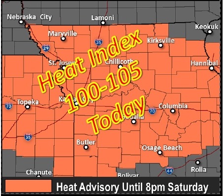
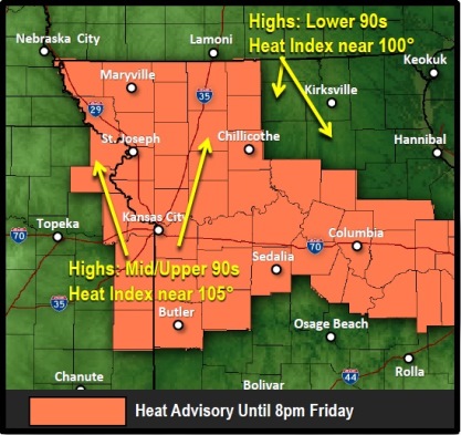
Temperatures today may top out at 95 degrees, with a heat index of 103, according to the National Weather Service.

A heat advisory will go into effect at 1 p.m. and last until 8 p.m. Friday.

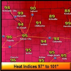
The temperature was already 86 degrees by 11 a.m., with a heat index of 91.

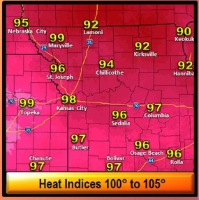
Similar temperatures are expected over the weekend, although humidity values and heat indices will be slightly lower, according to the weather service.

There is a 20 percent chance of thunderstorms late tonight. The severe weather and heavy rain threats are low.

Tips on handling the heat:

• Those exposed to the high heat and humidity over a prolonged period will have an increased risk of heat-related illnesses. Cars may reach lethal temperatures in minutes. Never leave children or pets unattended in a vehicle, not even for a minute.

• Drink plenty of water. Avoid caffeinated, alcoholic and high sugar content beverages.

• Stay in an air-conditioned room. Stay out of the sun.

• Check up on neighbors, the elderly and pets.

• If you work outside, reschedule strenuous activities to early morning or late evening.

• Know the signs and symptoms of heat exhaustion and heat stroke.

• Wear light-colored, lightweight and loose-fitting clothing when possible.

• Schedule frequent rest breaks in shaded or air-conditioned environments.

• Move anyone overcome by heat to a cool and shaded location and seek help by calling 911 immediately.

• If you don’t have air-conditioning, look for an air-conditioned public library, recreation center, Salvation Army at 67th and State, a store or other public place.

Hot in the Dotte

Wednesday highs (National Weather Service graphic)

Look for today’s temperatures to reach a high of 94, with a heat index of 99 today, according to the National Weather Service.

By noon, the temperature was already 91 degrees in Kansas City, Kan., with a heat index of 97.

Hot and humid conditions will continue for the rest of the week, the weather service says.

The hottest days will be Thursday through Saturday, with highs in the middle 90s and afternoon heat index values between 100 and 105.

Isolated thunderstorms will be possible this afternoon through the weekend, primarily across far northern Missouri, according to the weather service. Severe weather is not expected.

Increasing chances of thunderstorms are expected Monday into Tuesday across the area.

For more weather information, visit www.weather.gov.

Thursday highs (National Weather Service graphic)