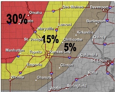
National Weather Service graphic
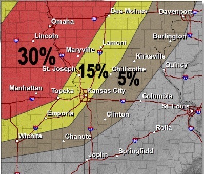
UPDATE: The National Weather Service has issued a severe thunderstorm warning from 9:58 p.m. to 10:45 p.m. Monday in Wyandotte County.
The storm was to the west of this area, and was moving east at 50 mph. Damage to siding, trees and roofs is possible, the weather service said. Wind gusts of 60 mph are possible. Residents are advised to move to an interior room.
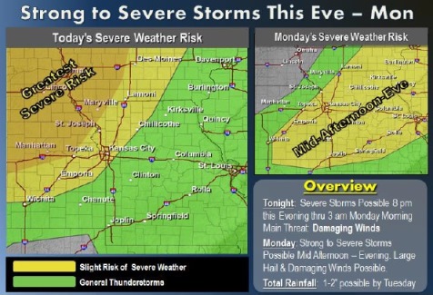
A thunderstorm is moving into the area tonight as a strong storm system and associated cold front approach, according to the National Weather Service.
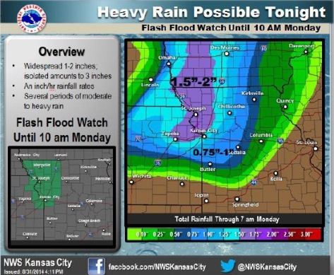
A flash flood watch will start at 9 p.m. Sunday and continue until 10 a.m. Monday. A thunderstorm watch is in effect from 8:15 p.m. Sunday to 4 a.m. Monday.
The weather service said storms could continuously redevelop over the same areas.
Small hail and damaging winds are possible.
A 90 percent chance of thunderstorms is possible, mainly after 1 a.m. in Wyandotte County, according to the weather service. Between 1 and 2 inches of rain are possible.
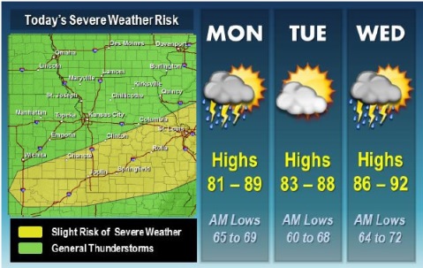
On Monday, Labor Day, showers and thunderstorms are possibly, mainly before 9 a.m. New rainfall amounts could be between a quarter and a half of an inch of rain. The high will be near 87.
Monday night, there is a 40 percent chance of showers and thunderstorms. It will be mostly cloudy with a low around 68.
Residents should be especially cautious at night when it is harder to recognize developing flash floods, the weather service said.
For more weather information, visit www.weather.gov. National Weather Service graphic Damaging winds (National Weather Service graphic) Large hail (National Weather Service graphic)
National Weather Service graphic
A 60 percent chance of rain is in the Wyandotte County forecast today, mostly after 3 p.m. into the evening, according to the National Weather Service.
Between a tenth and a quarter of an inch of rain is possible. Today’s high will be 84 degrees.
While the overall severe weather threat is low, a few storms will have the potential today for gusty winds and locally heavy rainfall, the weather service said.
The next widespread round of thunderstorms is expected Sunday evening into Monday morning. A few of these storms may be strong to severe, according to the weather service.
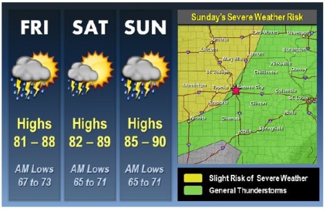
Saturday, there will be a 10 percent chance of storms and a high of 86. The rain is most likely before 7 a.m. Saturday. The rest of the day will be mostly sunny.
Sunday, skies will be mostly sunny with a high of 88.
On Monday, Labor Day, the forecast calls for a 40 percent chance of showers and thunderstorms. Skies will be partly sunny with a high near 86.