Rains bring cooler temperatures

After a morning rain, the chance of showers remains in the forecast through 4 p.m. Wednesday.

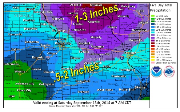
Heavy rains moved through the area last night and this morning.

River levels on the Missouri River at Kansas City are expected to rise from 15 feet on Wednesday to 20 feet on Saturday, and then decline. That is not near the flood stage level of 32 feet. The Kansas River also is well below the flood stage level.

Today’s high will be near 73, with a north northwest wind from 9 to 16 mph, gusting to 23 mph.

Tonight, the skies will be mostly cloudy, with a low of 52. A north wind of 9 to 14 mph, with gusts as high was 20 mph, is forecast.

Thursday, expect mostly sunny skies with a high near 67. A north northeast wind will be 8 to 10 mph.

Showers are back in the forecast for Friday, when there will be a 40 percent chance of rain. The high will be near 60. Winds will be from the north at 8 to 14 mph, gusting to 20 mph.

Temperatures are expected to be in the 60s on Saturday and Sunday.

Storms, rain likely today

National Weather Service graphic
A 50 percent chance of severe thunderstorms is in today’s National Weather Service forecast.

Several storms could visit the area this afternoon and early Wednesday morning.

Damaging winds and large hail are the most likely threats, with a chance of tornadoes near the Missouri-Iowa state border to the northwest.

Heavy rains are expected to accompany the storms, with areas along and north of Highway 36, near the St. Joseph, Mo., area, possibly receiving up to 2 inches of rain. Rain amounts near I-70 are expected to fall within the three-quarters of an inch to one-and-a-half inch range, according to the weather service.

Today’s high will be near 87, with south winds of 10 to 15 mph and gusts as high as 22 mph.

Cooler weather is expected Wednesday, with a high near 75. Thursday, the temperatures drop again, and the high will be near 66. On Friday, the high will be near 60.

Weekend weather is sunny and 64 on Saturday, and sunny and 72 on Sunday.

Monday’s sunny weather could be followed by showers on Tuesday

National Weather Service graphic

Monday’s weather is sunny with a high near 84, according to the National Weather Service.

The wind on Monday will be from the south at 8 to 13 mph.

On Tuesday, there will be a 50 percent chance of showers and thunderstorms. From a half-inch to 2 inches of rain could fall in the area, the weather service said. The chance of showers continues Wednesday.

The best chance on Tuesday for severe weather is along and north of I-70, and especially to the north of and near St. Joseph, Mo. Wind and hail are the main threats, with a slight chance for tornados.

By the end of the week, much cooler temperatures will move in. The lows will be in the 40s and 50s on Thursday and Friday morning, with highs in the 50s and 60s.

National Weather Service graphic