Flood watch in effect as heavy rains fall in area

Traffic was heavy on I-635 north near Kansas Avenue this morning, where there was an accident, according to KC Scout. (KC Scout photo)

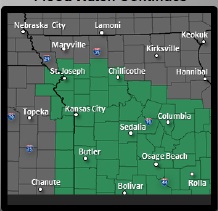
A flood watch is in effect until 7 p.m. Oct. 10 as heavy rains fell this morning in Wyandotte County.

According to the National Weather Service, there are several periods of heavy rain possible through Friday evening that could lead to flooding in the Kansas City area.

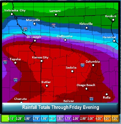
Rainfall totals could total from one to three inches with locally higher amounts possible. The potential for the heaviest rainfall will be across areas near and north of I-70 tonight, then shifting into areas south of I-70 by Friday morning, according to the weather service.

Those who are living in areas prone to flooding should be prepared to take action should flooding develop, the weather service said.

Today’s high will be 63 degrees. the low tonight will be 49.

A 60 percent chance of rain is in Friday’s forecast, and Friday night, there will be a 30 percent chance of rain.

As of this morning, the Missouri River at Kansas City and the Kansas River in Kansas City, Kan., were not anywhere close to the flood stage, according to the hydrologic charts from the weather service.

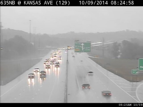
Those who are driving are advised to turn away and find another route if a road or intersection is covered by water.

Accidents were reported this morning by Kansas City Scout at I-635 before Kansas Avenue, and I-635 past Shawnee Drive.

Flood watch area (National Weather Service graphic)

Possible rainfall totals (National Weather Service graphic)

Nice weather Tuesday, rain predicted Wednesday

Mostly sunny skies on Tuesday will be followed by a chance of thunderstorms on Wednesday, according to the National Weather Service.

Today’s high will be 77 with winds from the northwest at 7 to 14 mph, and gusts as high as 18 mph.

Tonight’s low will be 51.

Wednesday, there is a 20 percent chance of rain and storms after 1 p.m.

Wednesday night brings a 70 percent chance of showers and thunderstorms. The low will be 60.

An 80 percent chance of thunderstorms and showers is in Thursday’s forecast, continuing into Thursday night with a 50 percent chance of rain.

Friday, there will be a 30 percent chance of rain with a high near 59. Friday night, skies will be mostly cloudy with a low of 47.

On Saturday, expect partly sunny skies and a high near 58.

Sunday, there is a 30 percent chance of showers with a high near 63.

Slight chance of rain in today’s forecast

There is a 20 percent chance of isolated showers before 1 p.m. on Monday, according to the National Weather Service.

Skies will be mostly sunny with a high near 72. The west northwest wind will be 7 to 13 mph.

Tonight, the low will be about 54 with mostly cloudy skies.

For Tuesday, look for mostly sunny skies with a high near 77. The west northwest wind will be 5 to 13 mph with gusts as high as 18 mph.

Tuesday night, expect a low around 53.

Wednesday’s weather will be mostly sunny with a high near 77. The wind will be calm, becoming east southeast around 6 mph in the afternoon.

Wednesday night, showers and thunderstorms are likely, mainly after 1 a.m. The chance of rain is 60 percent. The low will be about 61.

Thursday’s forecast is 50 percent chance of rain and storms, with a high near 72.

On Thursday night, there is a 50 percent chance of showers and thunderstorms with a low of 52.

Friday and Saturday weather has no rain predicted, with highs of 61 and 62.

Sunday’s weather includes a 30 percent chance of rain, with a high near 67.