Freezing rain, snow possible this weekend

Forecast snow totals through Saturday night. (National Weather Service graphic)

Freezing rain and snow may return to the area this weekend.

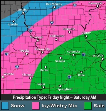
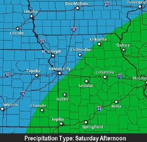
Starting late Friday evening, or possibly in the early morning hours Saturday, the winter storm could have a variety of precipitation types before changing to all snow late Saturday afternoon and evening, according to the National Weather Service.

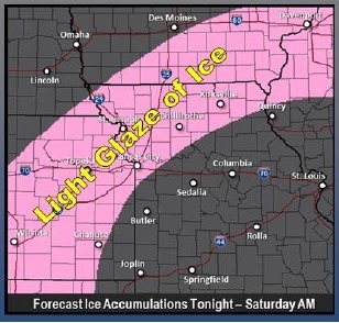
Some areas may get freezing rain after midnight Friday, forecasters said. Freezing rain may mix with light snow or sleet on the northern edge, according to the weather service. The wintry mix should end Saturday morning. There is a chance of ice.

Temperatures in the upper 20s to lower 30s Friday night, warming into the middle 30s on Saturday, will be the key to the types of precipitation, according to the weather service.

A light glazing to a few hundreds of an inch of ice could make for hazardous travel Friday night, forecasters warned.

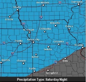
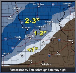
Snow will spread from the southwest to the northeast late Saturday afternoon through Saturday night. A light amount of snow may fall in the afternoon, and a few inches of snow are possible on Saturday night, the weather service said.

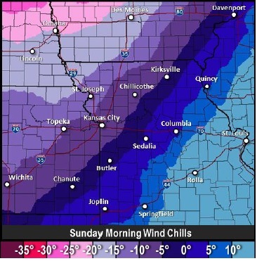
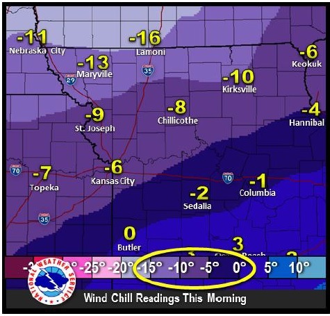
Temperatures will fall into the single digits to lower teens by early Sunday morning, and will be accompanied by northwest winds between 15 to 20 mph, the weather service said. Wind chills may be between minus 5 to minus 15 degrees before 11 a.m., according to the weather service.

Today’s high will be 36 degrees.

For the latest weather reports, visit www.weather.gov or listen to weather radio.

Ice accumulation forecast tonight and Saturday morning. (National Weather Service graphic)

Precipitation types Friday night and Saturday morning. (National Weather Service graphic)

Precipitation type Saturday afternoon. (National Weather Service graphic)

Precipitation type Saturday night. (National Weather Service graphic)

Wind chill Sunday morning. (National Weather Service graphic)

New Year’s weather a little warmer; storm system moves into area Friday night

Today’s high will be 33 degrees, and there will be mostly sunny skies to greet the New Year.

The temperature was 25 degrees at 10 a.m., according to the National Weather Service.

Tonight, expect a low of 24.

Friday’s forecast is mostly sunny, with a high near 37.

Wintry weather conditions return on Friday night, with freezing rain likely after midnight. It will be a 60 percent chance of precipitation. The low will be 29.

According to the weather service, while there is confidence in the timing of the precipitation, there is still some doubt at this point about the temperatures at the time of the precipitation.

The precipitation is expected to spread from the south to the north late Friday night. Some sort of wintry mix is expected over the entire area, the weather service said. Initial cooling may allow some ice pellets to form. Some freezing rain and a light glaze of ice are possible along and south of the Missouri River.

Saturday, expect rain, snow and freezing rain, becoming all snow, after noon. The high will be near 35. The new snow accumulation will be less than one inch.

There is a potential for a moderate snowfall during Saturday afternoon and evening. On Saturday night, there is an 80 percent chance of snow before midnight, with a low of 11.

At this time, snowfall amounts could be from 2 to 4 inches along and north of a line from Leavenworth to Unionville. Elsewhere, the snowfall could be 1 to 2 inches.

The precipitation should exit the area by late Saturday night. Then, cold and dry weather will follow.

Sunday, skies will be mostly sunny with a high near 16. Sunday night, there will be partly cloudy skies and a low of 9.

Monday, it warms up a little to a high near 26. Tuesday’s high will be 28, and Wednesday, the high will be 23.

2014 exiting on a cold note

Cold temperatures Wednesday morning. (National Weather Service graphic)

The last day of 2014 may go out as one of the coldest days of the year.

The temperature was 8 degrees at 9 a.m. Wednesday, Dec. 31, with a wind chill of minus 1. Earlier in the morning the wind chill was minus 6.

The National Weather Service warned residents about the sub-zero wind chills across the region.

It will warm up a little bit tonight and also on New Year’s Day.

There is a good chance of wintry precipitation late Friday night through Saturday night, the weather service said.

It is too early to determine potential snowfall totals Friday night and Saturday, although preliminary data indicates that 1 to 2 inches of snow is possible, according to the weather service.

The day-to-day forecast from the weather service:

This afternoon’s high will be 22 degrees with sunny skies.

Tonight, it will be partly cloudy with a low around 17.

For New Year’s Day, the weather will be mostly sunny with a high near 34. Thursday night, there will be partly cloudy skies with a low around 25.

On Friday, expect mostly sunny skies with a high near 36. Friday night, there will be a 30 percent chance of snow with a low of 27.

Saturday’s forecast is a 50 percent chance of snow before noon, then a chance of rain and snow. The high will be near 36. Saturday night, the low will be around 13.

Sunday, expect a high near 22. Monday’s high will be near 30.