Area warms up a little today, after dangerously cold morning

National Weather Service graphic

One of the coldest days of the year began with dangerously cold subzero wind chills this morning in Wyandotte County.

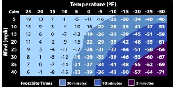
The temperature was 3 degrees around 1 a.m., and 5 degrees at 4 a.m., with wind chill readings of minus 9 and minus 11.

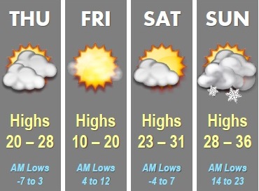
But temperatures climbed to 15 degrees by 10 a.m., with a wind chill of zero, according to the National Weather Service. Today’s high is expected to be 27, as the area climbs out of the deep freeze.

Another surge of cold air is expected Friday night, that could bring wind chills into the minus 10 to minus 15 range in the region.

The weather service said there is a chance of scattered snow flurries between noon and 5 p.m. Thursday. Today’s wind will be 17 to 21 mph with gusts as high as 33 mph.

Tonight, it will be partly cloudy with a low around 8. The wind chill will be between minus 6 and 4. The west wind will be 13 to 15, changing to north northwest after midnight. Winds may gust as high as 22 mph.

Friday’s high will be near 15, with a wind chill between minus 8 and 2. Northwet winds will be 10 to 13 mph with gusts as high as 18 mph.

Friday night, it will be mostly clear, with a low around 4. The wind chill will be between minus 3 and 2. The west northwest wind of 5 to 8 mph will become light and variable in the evening.

Saturday’s forecast is mostly sunny, with a high near 28. There will be a south wind of 5 to 13 mph.

Sunday, it will be partly sunny with a high near 35. Sunday night, there will be a 30 percent chance of snow, with a low around 23.

Monday, the 30 percent chance of snow continues, with a high near 30.

Wind chill advisory in effect today through Thursday morning

National Weather Service graphic

A wind chill advisory is in effect today through 9 a.m. Thursday, according to the National Weather Service.

The wind chill was minus 7 at 9 a.m. Wednesday, with the temperature at 9 degrees in Wyandotte County. There was a light dusting of snow overnight.

From now until 9 a.m. Thursday, the wind chill advisory in effect means that frostbite is a danger, the weather service said. Frostbite may occur in 30 minutes or less if skin is exposed, the weather service stated. Hats and gloves are needed along with warm winter coats.

Skies will be sunny today and the cold will continue, according to the weather service. A north wind of 15 to 20 mph will decrease to 9 to 14 mph in the afternoon. Winds may gust as high as 28 mph on Wednesday.

Tonight, the forecast is mostly clear with a low around minus 1. The wind chill will be between minus 7 and minus 14. The winds will be light and variable after midnight.

The coldest hours will be from 4 a.m. Thursday through 8 a.m. Thursday, the weather service said.

Thursday, the forecast is mostly sunny and a high of 25. The wind chill will be between minus 5 and minus 15. The south wind of 11 to 20 mph will change to the west in the afternoon. Winds may gust up to 30 mph.

Friday, the forecast is sunny and a high near 16. The wind will be 6 to 14 mph with gusts as high as 20 mph.

Saturday, the high will be near 29, and Sunday, the high will be near 34.

Wind chills today, left, and Thursday morning, right. (National Weather Service graphic)

Wind chill advisory in effect on Wednesday

A wind chill advisory starts 3 a.m. Wednesday and lasts until 9 a.m. Thursday. (National Weather Service graphic)

A wind chill advisory will be in effect from 3 a.m. Wednesday to 9 a.m. Thursday, according to the National Weather Service.

Today, the forecast states there will be a high of 19 degrees with mostly sunny skies. Wednesday, the high will be 7 degrees while overnight lows will range from 4 degrees to minus 1, according to the weather service forecast.

Wind chills in the area are expected to be 15 to 25 below zero during early Wednesday through Thursday morning, the weather service said. The coldest will be Wednesday morning and again early Thursday morning.

Temperatures will be between 0 and 5 below late tonight and again Wednesday night, the weather service said. Temperatures will not rise out of the single digits on Wednesday.

Winds will be 10 to 20 mph with gusts up to 30 mph, the weather service said. The strongest winds will be Wednesday morning and again Thursday morning.

Frostbite can occur in 30 minutes or less if skin is exposed, according to the weather service.

There will be frostbite and hypothermia if precautions are not taken, the weather service said. If you must venture out, dress warmly and wear a hat and gloves, according to the weather service.

On Thursday, temperatures will climb again to 26 degrees. Friday’s high will be 18.

Wind chills Wednesday morning, left, and Thursday morning, right. (National Weather Service graphic)

Temperatures, wind chills and time until frostbite sets in. (National Weather Service graphic)