Today’s forecast back in the freezer

Tuesday's wind chill forecast. (National Weather Service graphic)
Tuesday’s wind chill forecast. (National Weather Service graphic)

The weather is back in the freezer, but expect a warm-up on Thursday, according to the National Weather Service forecast.

According to the National Weather Service, the first half of the week will be very cold.

Monday morning, the temperature at 8 a.m. was 21 with a wind chill of 11 degrees. Today’s high will be near 23. A north wind will be from 11 to 14 mph, with gusts of 20 mph.

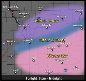
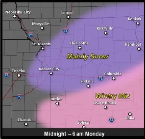
Several accidents were reported throughout the metropolitan Kansas City area this morning, on slick roads.

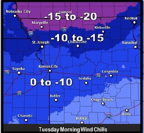
Tuesday morning will be the coldest, the weather service said, with a wind chill low of minus 15 in some areas of the region. Here, the wind chill will be as low as minus 7, according to the forecast.

Tuesday night there will be a chance of flurries, with a low of around 16, the weather service said.

Wednesday, the high will be near 31, and skies will become mostly sunny, according to the weather service.

Thursday will almost be a heat wave with a high of 41. Friday’s high will be near 50, and Saturday’s and Sunday’s, near 48, the weather service said.

Sleet, snow possible today

National Weather Service graphic

A little sputtering of very light rain was seen this morning in Wyandotte County, as the National Weather Service warned of the further possibility of snow and sleet today.

The temperature was 38 degrees at 11 a.m., and the weather service predicted a wintry mix across the region today, with a chance of light snow accumulation.

There is a 30 percent chance of precipitation this afternoon, mainly after 4 p.m. Tonight, there is a 40 percent chance of rain, snow, freezing rain and sleet before midnight, then a slight chance of snow between midnight and 3 a.m., the weather service said. Between a tenth and a quarter of an inch of precipitation is predicted, according to the weather service. Tonight’s low will be around 18.

Areas near and south of the Missouri River which get above freezing this afternoon may see the wintry mix change to rain before changing to snow this evening, the weather service said.

About an inch of snow is possible for parts of the region with amounts tapering to the southwest, and this area might receive as much as a quarter-inch of snow. A thin glaze of ice is possible south of the Missouri River, the weather service said.

To see the latest weather reports, visit www.weather.gov.

National Weather Service graphic

National Weather Service graphic

National Weather Service graphic

National Weather Service graphic

National Weather Service graphic

Dangerous wind chills in Friday’s forecast

Wind chill values tonight will drop below zero, ranging from minus 3 to minus 16, according to the National Weather Service.

This morning, the wind chill was minus 3 at 9 a.m., and the temperature was 13, according to weather service information.

Today’s high will be 17 degrees. A west northwest wind will be 8 to 11 mph with gusts as high as 23 mph, the weather service said.

Tonight, it will be clear with a low around 5, according to the weather service. The wind chill will be between minus 4 and 1. A west northwest wind of 5 to 7 mph will change to the south after midnight.

Saturday, it will be mostly sunny with a high near 32. Wind chill values will be between minus 7 and 3, according to the forecast. There will be a south wind of 6 to 15 mph, with gusts as high as 21 mph.

On Saturday night, expect a low of 22. The south wind will be 8 to 11 mph, according to the weather service.

The weather service said a wintry mix of precipitation is anticipated for Sunday through Sunday night.

Minor accumulations may be possible across portions of the region as well as a light glazing of ice, according to the weather service.

On Sunday, the high will be near 35, with south southwest wind of 5 to 7 mph, the forecast predicted.

Sunday night, the low will be near 20, with a 30 percent chance of precipitation in the form of snow, freezing rain and sleet, the weather service said.