Today, temperatures may rise enough for the snow to melt in Wyandotte County, but more snow will be on the way on Wednesday, according to the National Weather Service.
Today the high may be 48 degrees with sunny skies, the weather service said.
But cold arctic air is headed our way on Wednesday, and temperatures will drop all day, according to the forecast. Temperatures will start at about 25 degrees at 6 a.m. Wednesday, and by 6 p.m. will drop to about 18 degrees, according to the weather service.
Snow is likely to fall Wednesday, after noon, forecasters said. The chance of precipitation is 90 percent. From 1 to 3 inches of snow is possible, the weather service said.
Wednesday night, expect a low of 6, with a wind chill reading of between minus 4 and 1, along with winds gusting as high as 21 mph, according to the weather service.
Thursday’s high will be 27 degrees, then Friday, temperatures will rebound to a high near 48, the weather service said. Friday night, the low will be near 34.
Warmer weekend weather is on the way. Saturday, expect a high near 55, with mostly sunny skies, according to the weather service. Sunday, the high will be near 47. Monday’s high will be 46, the weather service said.
For more weather information, visit www.weather.gov.
Officially, today’s forecast from the National Weather Service is mostly sunny with a high near 26.
Unofficially, it’s Groundhog Day (http://www.groundhog.org/), and a Pennsylvania groundhog has seen his shadow today and predicted six more weeks of winter.
Tuesday, the temperatures here will rise out of the freezer to a high of 47, with sunny skies, according to the National Weather Service.
The National Weather Service forecast goes through next Sunday for the Kansas City area, and predicts a 50 percent chance of snow after noon on Wednesday, when the high will be near 31. A 30 percent chance of precipitation will be on Wednesday night.
From Friday through the weekend, it will warm up to the mid-40s and mid-50s.
Thursday, the high will be near 26; Friday, near 45; Saturday, near 53; and Sunday, near 46, the weather service said.
For more weather information, see www.weather.gov.
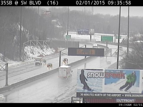
Traffic conditions on I-35 at Southwest Boulevard are shown Sunday morning. (KC Scout photo)
Wyandotte County has received a small blanket of snow overnight, with more snow falling this morning.
The National Weather Service said the main part of the snowstorm is to the north of the Kansas City area.
The weather service has issued a special statement for Wyandotte County that there will be potentially hazardous travel conditions this afternoon.
Winds will quickly increase from the north late this morning and this afternoon, with occasional gusts to 40 mph, according to the weather service.
This will lead to some areas of blowing snow, particularly near the I-70 corridor where 1 to 2 inches of snow have fallen in places, the weather service said. It may make it difficult to maintain clear roadways in these locations, according to the weather service.
Also, rapidly falling temperatures into the middle 20s this afternoon will cause any slush and water to freeze, especially on any untreated roadways, as well as bridges and overpasses, the weather service said. This may result in very hazardous and icy conditions in spots, according to the weather service.
The weather service cautioned that motorists should be careful if traveling this afternoon and be prepared for quickly deteriorating travel conditions.
More snow mixed with rain is possible throughout Sunday, leaving roads wet and slushy, the weather service said. Snow will taper off in the afternoon and late Sunday throughout the region, according to the weather service.
The temperature was 34 at 9 a.m. Sunday in Wyandotte County and according to the weather service, is expected to be 31 degrees at noon, 24 degrees at 3 p.m. and 20 degrees at 6 p.m. Temperatures are expected to keep dropping and by 3 a.m., should be around 12 degrees, according to the weather service.
Strong and gusty north winds will bring falling temperatures this afternoon and could refreeze roads overnight, according to the weather service.
Wyandotte County is not under the winter weather advisory, but counties to the north in Missouri, including Clay and Platte counties, are under that advisory.
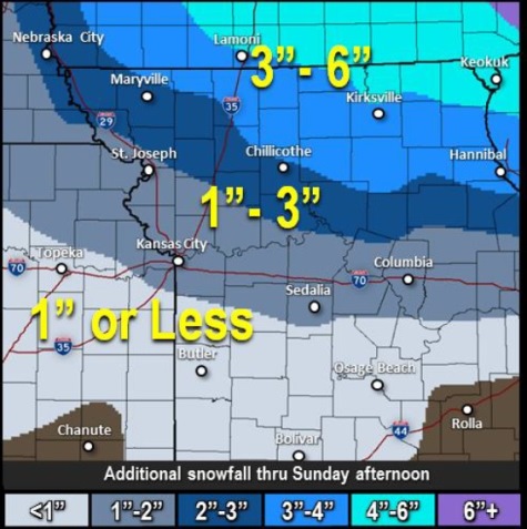
For more information about the weather, visit www.weather.gov. It appeared that there was more snow on the north side of Wyandotte County, from this photo at I-435 and Leavenworth Road on Sunday morning. (KC Scout photo) Traffic conditions are shown at I-70 and I-635 in Kansas City, Kan., on Sunday morning. (KC Scout photo) Predicted snowfall amounts for Sunday from the National Weather Service. (National Weather Service graphic) A close-up look at the snow Sunday morning in Wyandotte County. (Staff photo) Sidewalks and driveways showed varying layers of snow on Sunday morning in Wyandotte County. (Staff photo)