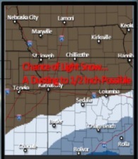
National Weather Service graphic
Today’s forecast includes a 50 percent chance of snow, mainly before noon, according to the National Weather Service.
However, it’s iffy whether Wyandotte County will get any, or very much, of the snow. Wyandotte County is again on the edge of the area predicted to have snow.
The main part of the storm will be south of an Olathe, Kan., to Boonville, Mo., line this morning through the early afternoon, which is south of Wyandotte County.
Today’s high will be near 28, according to the weather service, with a north wind of 10 to 13 mph.
Tonight, the low will be around 11, the weather service said.
Thursday, it will be sunny and the high will be near 31, according to the weather service. Thursday night’s low will be near 22.
Look for a warmup on Friday, when it will be sunny and a high of 49, the weather service said. A south southwest wind will be 10 to 15 mph with gusts as high as 22 mph.
Saturday, it will be sunny with a high of 57, according to the weather service. Sunday’s forecast is mostly sunny with a high near 58. Snow accumulations. (National Weather Service graphic)
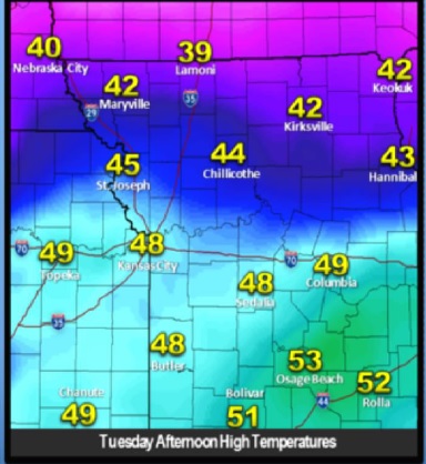
Temperatures today. (National Weather Service graphic)
The forecast today, Election Day, for Wyandotte County is warmer, as temperatures will reach a high near 48 degrees, according to the National Weather Service.
While there is snow predicted this afternoon for the region, it currently appears to be south of a Gardner, Kan., to Boonville, Mo., line, which is south of Wyandotte County, according to the weather service. Freezing drizzle and freezing rain are possible with that storm, the weather service said.
The temperature was 41 degrees in Wyandotte County at 8 a.m., according to the weather service. It was a little misty in some areas this morning. A southwest wind of 10 to 17 mph will become north northwest in the afternoon, and winds could gust as high as 26 mph, the weather service said.
A cold front is expected to move through the region this afternoon, according to the weather service. The high of 46 degrees is expected around noon today. Temperatures will begin falling, and at 3 p.m., the high may be 45 degrees, according to the weather service. At 6 p.m., the high may be 40 degrees.
Around 9 p.m. today, temperatures will drop to 32 degrees, the freezing point, and at midnight, to 26 degrees.
No precipitation is expected in Wyandotte County until 6 a.m. Wednesday, when there is a slight chance of snow, and temperatures will be 17 degrees.
Wednesday, there will be a 20 percent chance of snow in the morning, lasting until 1 p.m., the weather service said. The high will be near 28, and a north wind will be 10 to 14 mph with gusts as high as 18 mph.
Wednesday night’s low will be around 11, the weather service said.
Thursday, skies will be sunny and the high will be near 33, according to the weather service. Thursday night’s low will be 23.
Friday, expect sunny skies with a high near 48, the weather service said. The low Friday night will be around 30.
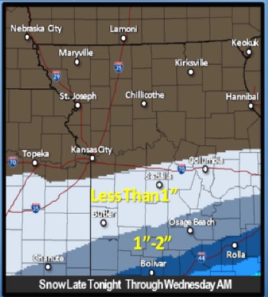
Saturday will be springlike with sunny skies and a high of 51, according to the weather service. Sunday’s and Monday’s high may be near 54, the weather service said. Snow tonight south of the Kansas City area. (National Weather Service graphic)
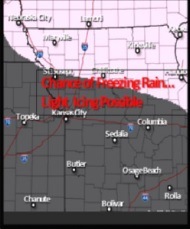
A chance of freezing rain and light icing is in the forecast tonight north of the Kansas City area. (National Weather Service graphic)
A little bit of everything is in the forecast from the National Weather Service today. But for Wyandotte County, the forecast now is showing that it is outside the main area for freezing rain tonight and snow on Tuesday night.
As weather conditions may change, keep up with the weather conditions at www.weather.gov.
Today’s high will be near 37, the weather service said.
Light rain will spread into an area north of Kansas City, Kan., tonight, where temperatures will be below freezing, the weather service said. This area now appears to be around St. Joseph, Mo., along and north of Highway 36, according to the weather service.
There is a 50 percent chance of rain, mainly after 9 p.m., here, the weather service said. The low will be about 33 degrees. A south wind of 10 to 16 mph, with gusts as high as 24 mph, is in the forecast according to the weather service.
Tuesday morning, temperatures will rise above freezing and the freezing rain will change to all rain, the weather service said.
There is a 30 percent chance of rain, mainly before noon, on Tuesday, Election Day. The high will be near 47 degrees, according to the weather service. It will be windy, with a south wind of 15 to 21 mph becoming north northwest on Tuesday afternoon, the weather service said. Winds may gust as high as 29 mph, the weather service said.
Behind a cold front, on Tuesday night, light snow will be possible south of Highway 50, which is south of Wyandotte County, and includes Butler, Mo., Columbia, Mo., and Sedalia, Mo., according to the weather service.
Tuesday night’s low for Wyandotte County will be around 16 degrees, with a north wind of 13 to 15 mph, gusting to 21 mph, according to the weather service.
Wednesday, skies will be partly sunny, with a high near 28, the weather service said. The north northwest wind will be 11 to 15 mph, with gusts as high as 21 mph.
Wednesday night’s low will be around 11, and Thursday’s high will be near 34, the weather service said.
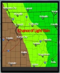
There is a chance of light rain on Tuesday east of Wyandotte County, according to the National Weather Service. (National Weather Service graphic) An area south of the Kansas City area may receive some light snow on Tuesday night. (National Weather Service graphic)